A brutally hot and humid Southern California August and a record-breaking wildfire season across interior PacNW & beyond
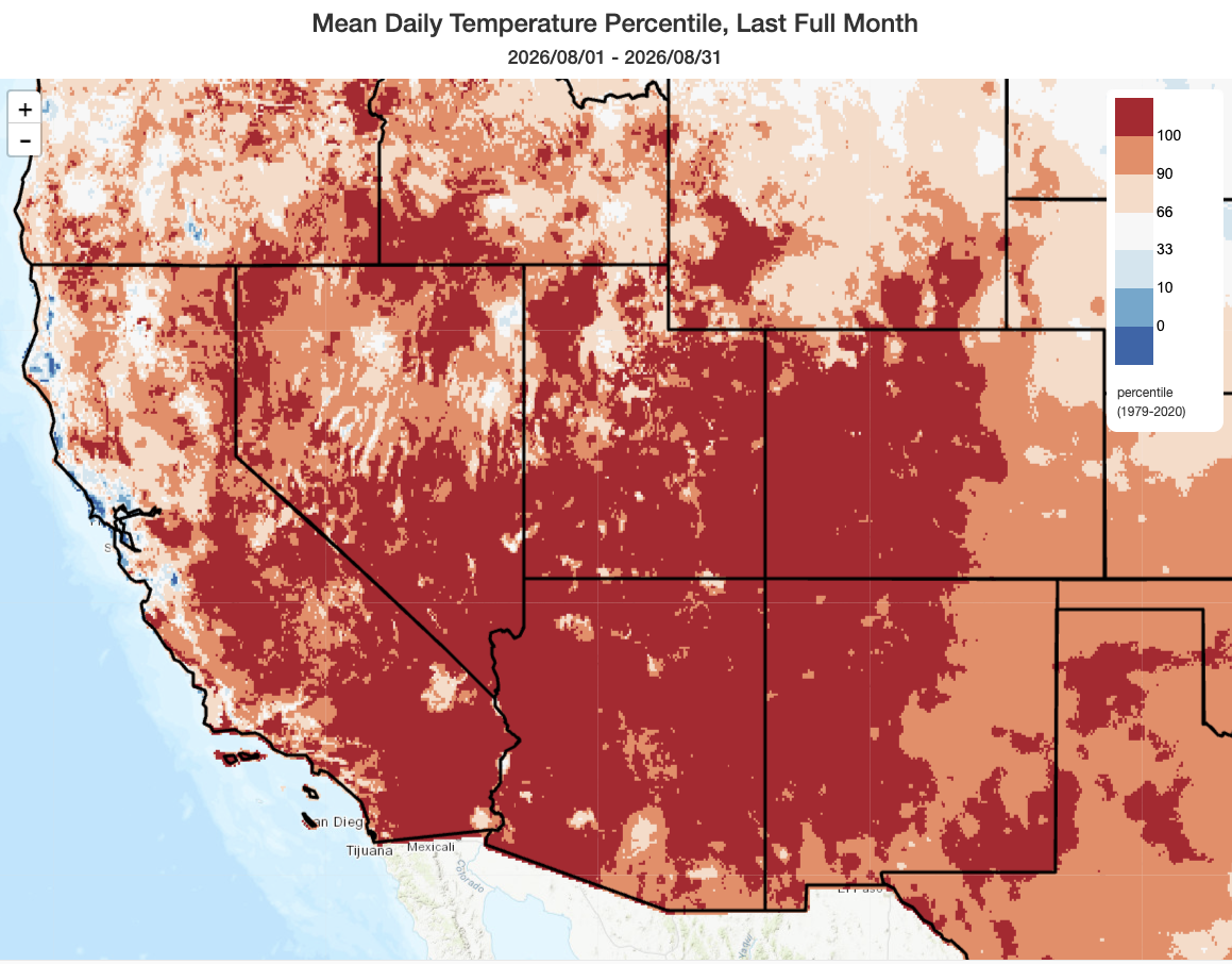
August ended up being an exceptionally hot month across nearly the entire Southwestern U.S., including across nearly all of SoCal (even coastal areas). In fact, August was (yet again) a record warm month in many locations; in places that didn’t set monthly records, it was almost universally in the top 3 warmest on record. While there were some very hot days, a lot of this extraordinary warmth was boosted by incredibly high overnight minimum temperatures–which in some locations failed to fall below 70 degrees the entire month, and on some nights below 80-90 degrees in elevational thermal belts and deserts.
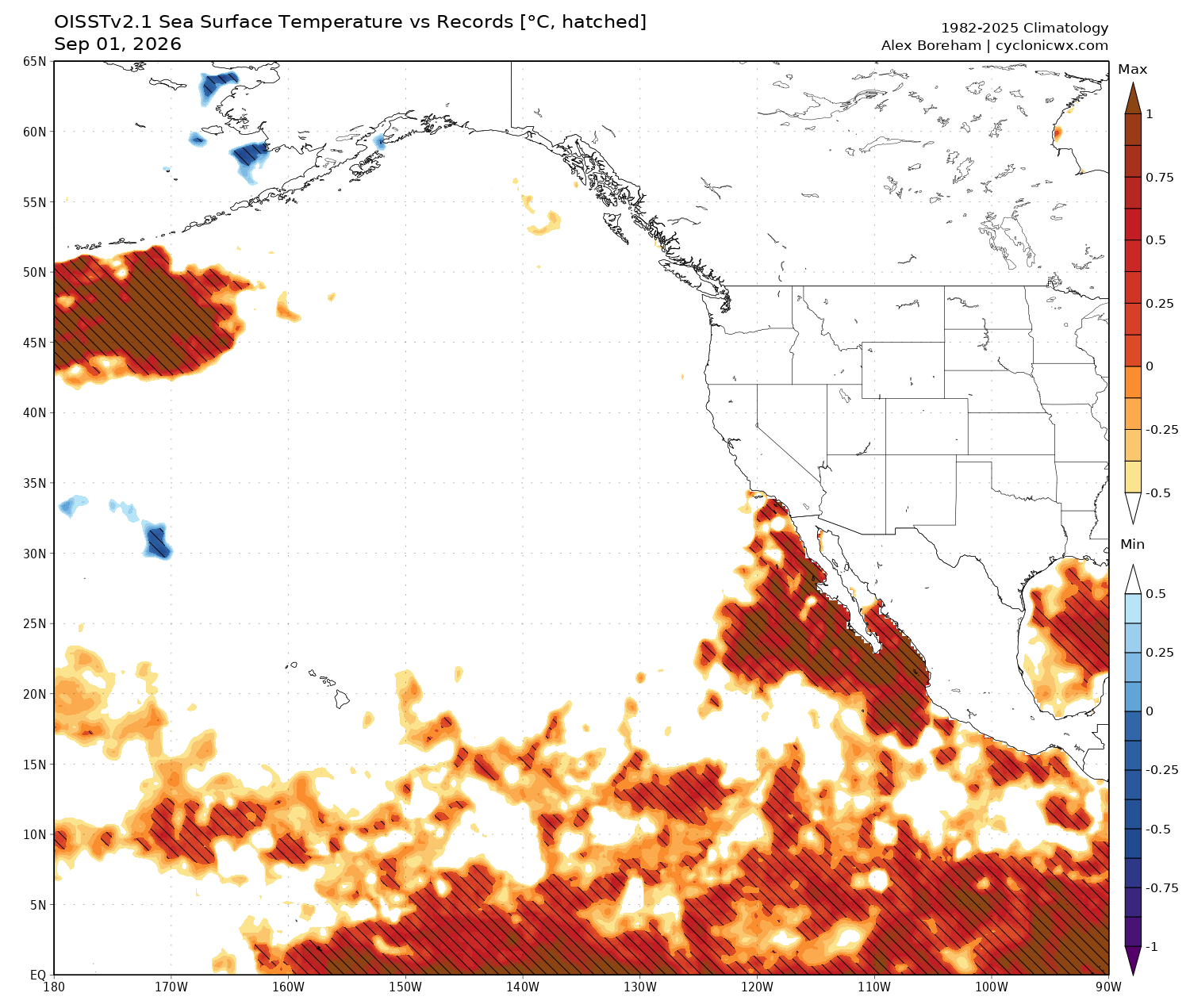
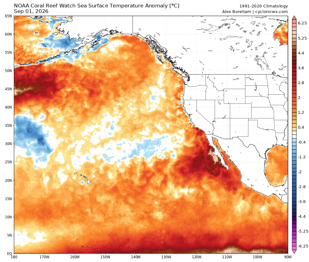
Worse than the heat, though, was the unrelenting and miserable humidity that pervaded all of southern California as well as some interior parts of the West (including the Sierra Nevada and Great Basin). This was anything but a “dry heat,” and it greatly amplified the human health impacts of long-duration heat events in places like Los Angeles, San Diego, and Las Vegas (this is why the National Weather Service issued frequent and long-duration heat advisories/warnings for much of the month). This extremely elevated humidity had multiple causes and source regions, but the most obvious culprit is the vast expanse of near-record or record-warm ocean waters extending clear from the coast of Peru to near Point Conception (west of Santa Barbara). This huge expanse of far warmer than average surface waters contributed to greatly higher than usual evaporation from a large swath of ocean, contributing not only to a local zone of enhanced near-surface humidity along the coastal SoCal metros but also juicing up the entire atmospheric column this summer. Extreme monsoonal thunderstorm downpours across parts of Arizona, Nevada, Utah, and Colorado were, themselves, substantially worsened by this exceptionally high water vapor availability; severe and in many cases deadly flash floods were the unfortunate result.
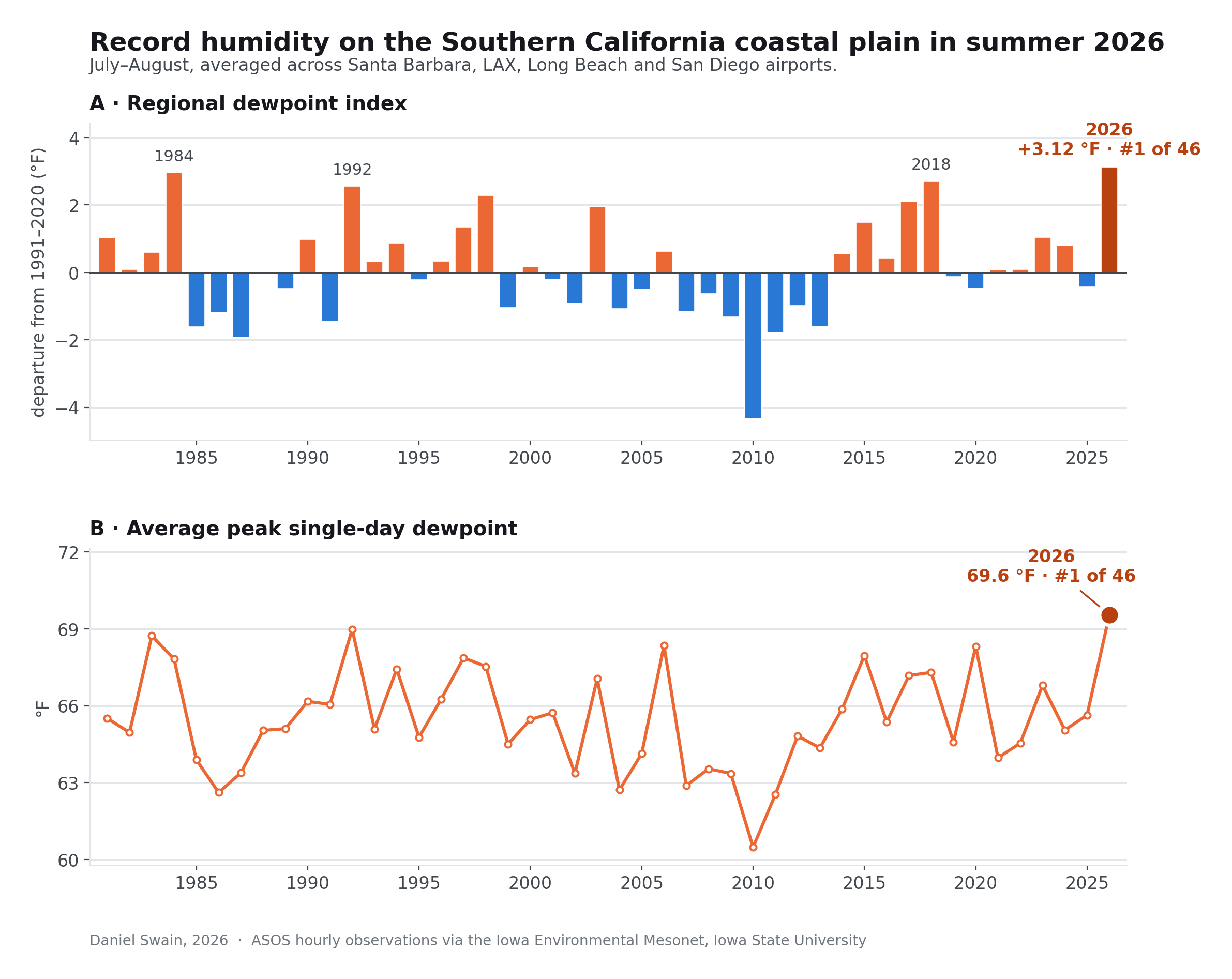
While reliable humidity data is surprisingly hard to come by (for a variety of reasons), I did take a quick and informal look using a representative sample of weather stations on the SoCal coastal plain for June-August 2026. And the numbers bear out the miserable anecdotal experience folks have reported: Summer 2026 was genuinely the most humid on record in coastal SoCal when considering dewpoint temperature, which is reliable and inter-comparable measure of absolute humidity. Notably, many locations not only saw record-breaking duration of elevated humidity but also experienced their single most humid days on record, with dewpoints exceeding 70F on more than a few locations making it feel more like the Amazon rainforest than LA summer (and yes, I do mean that literally!).
While humidities are currently down from their peak in late August, they will likely rise again shortly and could remain extremely elevated relative to historical norms well into autumn or even winter in SoCal.
Early season trough and associated cut-off low will bring cooler, wetter early September weather to PacNW & NorCal
It has been a terrible fire season across much of the interior West, and the epicenter has arguably been across the interior Pacific Northwest, from the crest of the Cascades eastward. Indeed, Fire Season 2026 has broken or even shattered many records, including: 1) The most area burned, in any full season, in Oregon and also in Oregon and Washington combined, and the second most area burned in Utah, and 2) The single most destructive fire season on record (in terms of structures lost) in Washington, Nevada, and possibly Utah, and the second most destructive on record in Colorado. And many fires are still burning, including in remote and heavily forested mountainous regions.
That’s why it’s very good news, indeed, that widespread soaking and perhaps (in some cases) fire season-ending rainfall is expected in the coming days across precisely this region. Many of the currently burning fires deep in the Cascade Range forests could have become a huge problem had a large wind event arrived before widespread multi-inch rainfall in this region. That’s especially true due to the already severe and still-expanding drought in this region combined with the “dry autumn” teleconnection that a developing El Nino event often yields here.
Fortunately, however, this rain will be well-timed, and is much-needed. While this will not necessarily be enough to end fire season east of the Cascades, it will still help greatly and mitigate the risks associated with autumn offshore wind events here. (Conversely, the incoming trough and dry winds associated with it will increase fire risk farther east, across the Central Rockies, but at present this still appears to be a net positive trade-off).
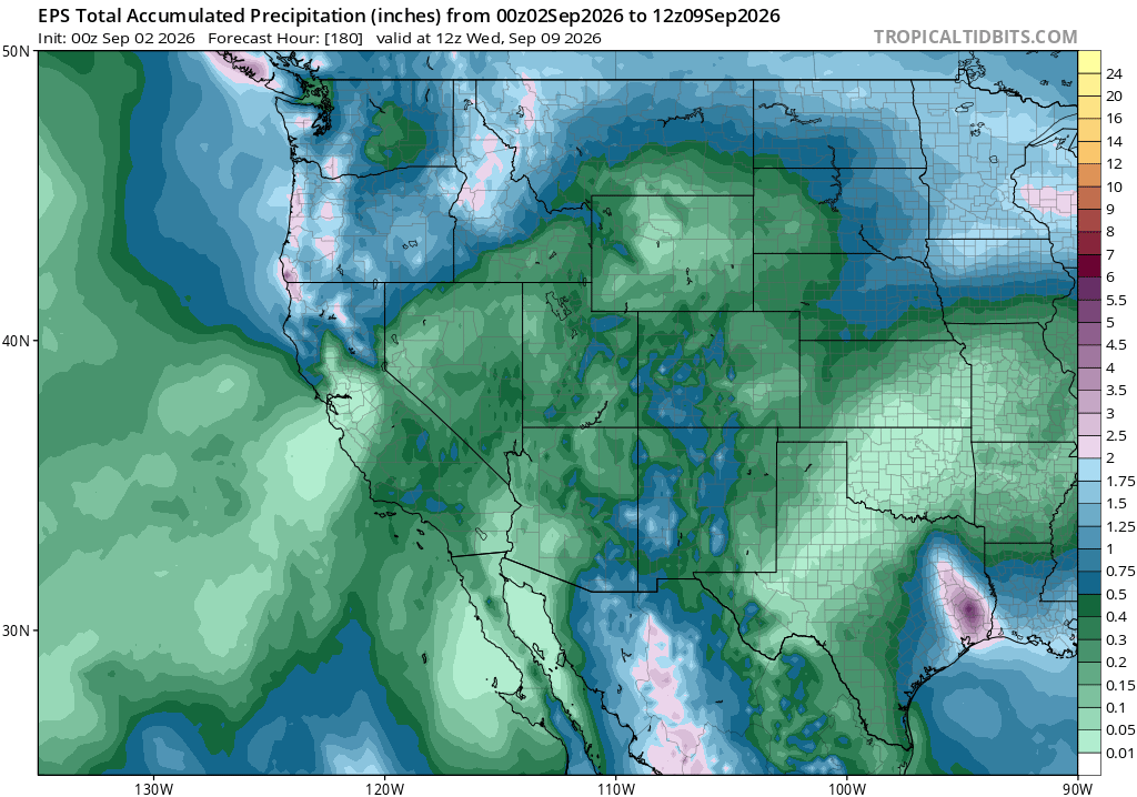
Precipitation associated with this trough and associated cut-off low will also move into portions of NorCal as soon as Thursday, and will deliver a quite solid soaking to some areas (especially the North Coast and northern mountains), with some light showers possible as far south as the SF Bay Area. While this will probably not be a fire-season ending rain in NorCal, at least away from the North Coast, it will still substantially offset the effects of recent heat (and since there is no severe drought in California at this time, it will have a more lasting beneficial effect than would otherwise be the case).
Temperatures across the Pacific Northwest and northern California will also be much cooler during this period, with some southwesterly breezes at times. SoCal will be cooler, too, but temperatures and humidity there may once again rise after a brief cooldown. Notably, near-shore ocean temperatures are now well above average along the entire CA coast, and have reached or exceeded historic record levels once again in the SoCal Bight (as well as across most of the Eastern Pacific between California and the Galapagos Islands).
The big wildcard: Marie’s remnants may bring showers, thunderstorms, renewed humidity, high surf & coastal flooding, and/or a period of critical fire weather to SoCal this weekend. Or…not.
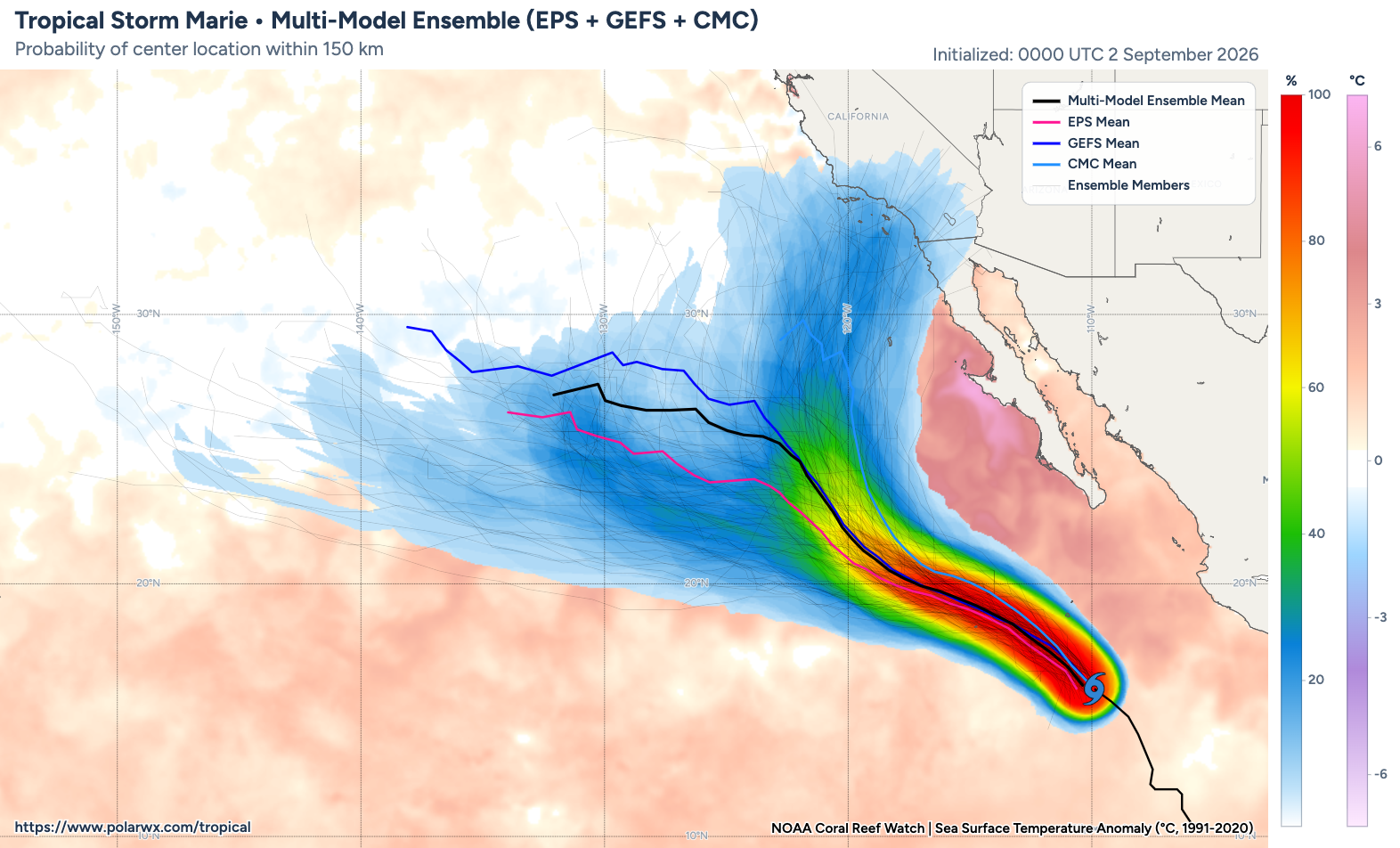
Earlier this week, there was quite a flurry of social media posts and news headlines surrounding the potential for a “hurricane in LA.” Some social posts showcased unlabeled snapshots of highly extreme rainfall and very strong winds associated with direct landfall of a tropical cyclone (at tropical storm strength) near Los Angeles–without offering further context.
Well, the context is this: The odds of an actual hurricane landfall from this particular weather setup was, and remains, essentially zero. As I’ve discussed in the past: Such an occurrence is a theoretical possibility, and I would not be too surprised if it happens sometime in the coming decades as oceans warm and as the northeastern Pacific near SoCal becomes somewhat less aggressively hostile for tropical systems to survive their northward treks. But it would take a truly extraordinary sequence of events. We do have extraordinarily warm, and in some cases record warm, water west of Mexico and in the SoCal Bight–so we are checking that box. But what we do not have is an extremely strong cat 4/5 hurricane moving rapidly northward toward California. That’s really the only case where a true hurricane landfall in California could happen, and it isn’t going to happen with Marie.
Now, it is true that 10-20% of model ensemble members were, for a time, showing what would legitimately be an intact tropical storm-strength landfall somewhere between Santa Barbara and San Diego over the weekend. This was genuinely notable, since it would have potential to be a high-impact weather event (mainly from a heavy rain/flooding high wave/coastal flooding perspective). But dramatic social media posts aside, the cross-ensemble likelihood of a direct tropical storm landfall was never higher than 10-20%, and has since decreased (I’d say it’s now around 5%–quite low, but non-zero). But’s there still quite a bit of uncertainty regarding Marie’s eventual trajectory, and the fate of Marie’s subsequent remnants once the storm eventually weakens over cooler waters.
This still considerable uncertainty arises, primarily, from the varying degrees of interaction between the incoming mid-latitude Pacific trough/cut-off low pressure system with Marie (the tropical system) portrayed by different model ensemble members. In the (now minority) of ensemble members where this interaction is significant, Marie gets “picked up” in the southwesterly flow near the base of the trough and its remnants are shuttled toward southern or central California–potentially bringing copious tropical moisture and instability into the region, with widespread showers and thunderstorms (possibly heavy). In the ensemble members where this “phasing” between the trough and tropical storm does not occur, or only does so weakly, most of Marie’s remnant moisture remains offshore (and in some cases bypasses California entirely to the west). This latter scenario is now portrayed by a majority of model ensemble members, though even here some moisture could still make it to SoCal this weekend and produce (lighter and less widespread) isolated to scattered showers and thunderstorms.
So, what’s going to happen? Well, as of Wednesday afternoon, I still don’t know for sure (and neither does anyone else). I’d summarize the potential outcomes this way:
- Most likely outcome (~40-50% likelihood): Marie takes a primarily northwesterly trajectory away from California and does not substantially phase with the incoming trough, but some degree of remnant tropical moisture and atmospheric instability is still advected northeastward and Southern California sees lots of clouds, elevated humidity (yes, again!), and isolated to scattered showers (and perhaps some thunderstorms).
- Next most likely outcome (30-40% likelihood): Marie takes a more aggressively westerly trajectory, completely missing California. Relatively little deep moisture is advected northeastward, and California sees mainly mid and high-level cloudiness (and perhaps a sprinkle/dry thunderstorm or two). It could be quite warm and breezy in SoCal in this scenario, with locally strong and dry easterly winds in some spots, and that might lead to elevated to locally critical fire weather conditions.
- Least likely outcome (10-20% likelihood): Marie does manage to phase with the incoming trough and makes a right hook toward SoCal while rapidly weakening, with its center of circulation making a closer approach (an actual landfall would be an even lower likelihood subset of this outcome). If this occurs, more widespread heavy rainfall and thunderstorms are possible with an increased risk of flash flooding/debris flows, especially in the mountains.
In all three scenarios, high surf and large southerly swells are likely on the SoCal beaches; this, combined with already elevated sea levels associated with the ongoing marine heatwave and the rapidly strengthening El Niño event, could lead to dangerous conditions for beachgoers and also, possibly, to some coastal flooding.
Additional tropically-tinged weather events quite possible rest of Sep and Oct in CA; details TBD
Marie probably will not be the last tropical storm or hurricane to (potentially) have a significant influence on California weather this September or October. The northeastern Pacific basin has been extremely active lately, and with a El Niño by Oct leading to record warm ocean temperatures (high hurricane fuel) and low vertical wind shear (less storm-decapitating potential) the background conditions will be ripe for any early season trough or low pressure system to produce some fireworks.
There’s no guarantee this will happen; Marie’s a great example of the exquisite sensitivity of California weather outcomes to the particular temporal and spatial evolution of such events. Nevertheless, the preconditions have never been more favorable in recorded history than they will be over the next 2 months–so…stay tuned.
I’ll have another live YouTube update on latest regarding Marie on Friday morning (9/4)
See many of you at 10am PT on Friday 9/4!
Discover more from Weather West
Subscribe to get the latest posts sent to your email.