June ended up being a very warm (and warmer than expected) month in CA except at immediate coast
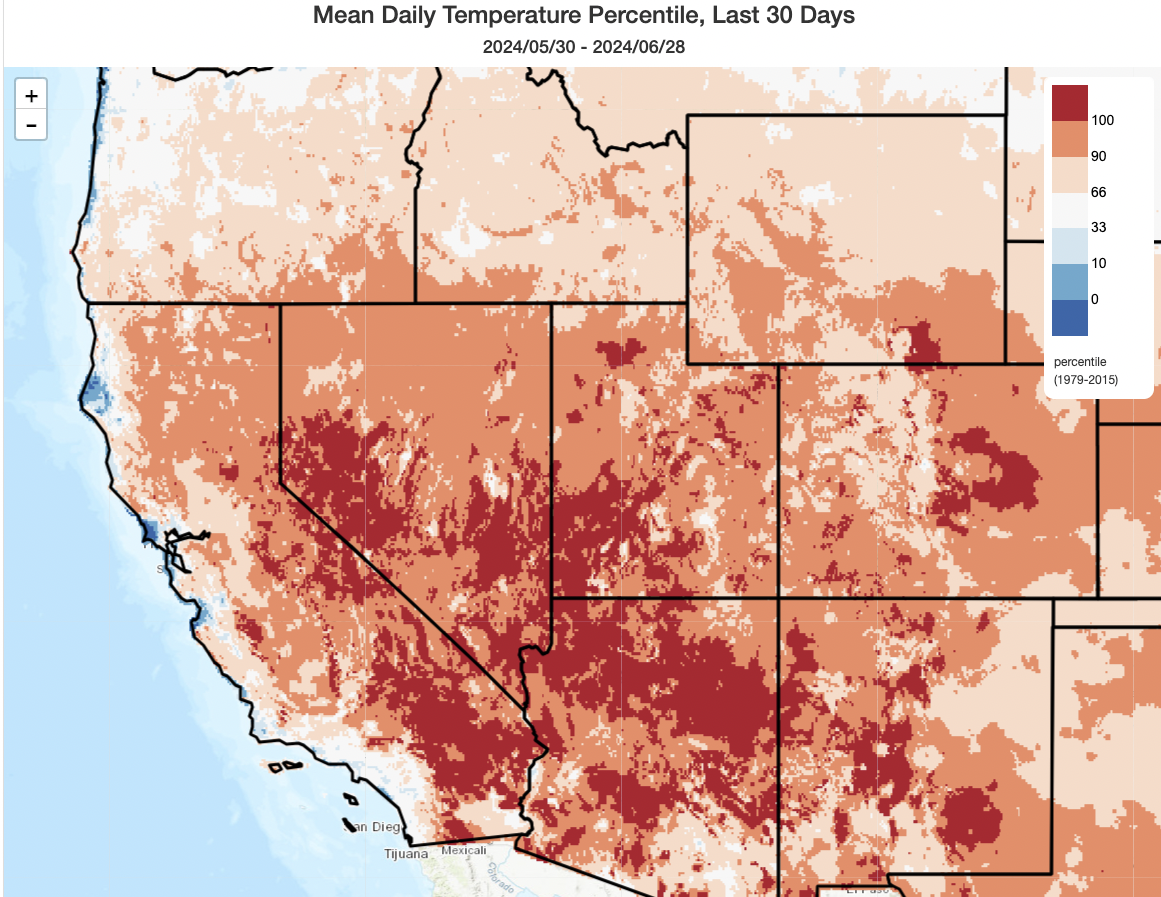
June was…well, a pretty toasty one across most of the Southwest (unless you happen to live close to the immediate Pacific coast!). In fact, across a large portion of the interior Southwest (including some desert and mountain locations in eastern CA), June 2024 has turned out to be among the warmest (if not the singular warmest) June on record. In Nevada, this was due to a combination of exceptionally hot daytime and nighttime temperatures (Las Vegas has broken nearly all its early season temperature records already this year), but in California was more directly caused by notably (and in many cases record-breakingly) warm overnight temperatures. So although record daytime highs were relatively few and far between, the cumulative nighttime warmth was enough to bring record overall temperatures in June in quite a few such spots.
Notably, the CA coast remained relatively cool for the most part in June–though not nearly to the same degree as it was in spring.
Notably long-duration heatwave will bring searing inland heat for many days, including very warm nights
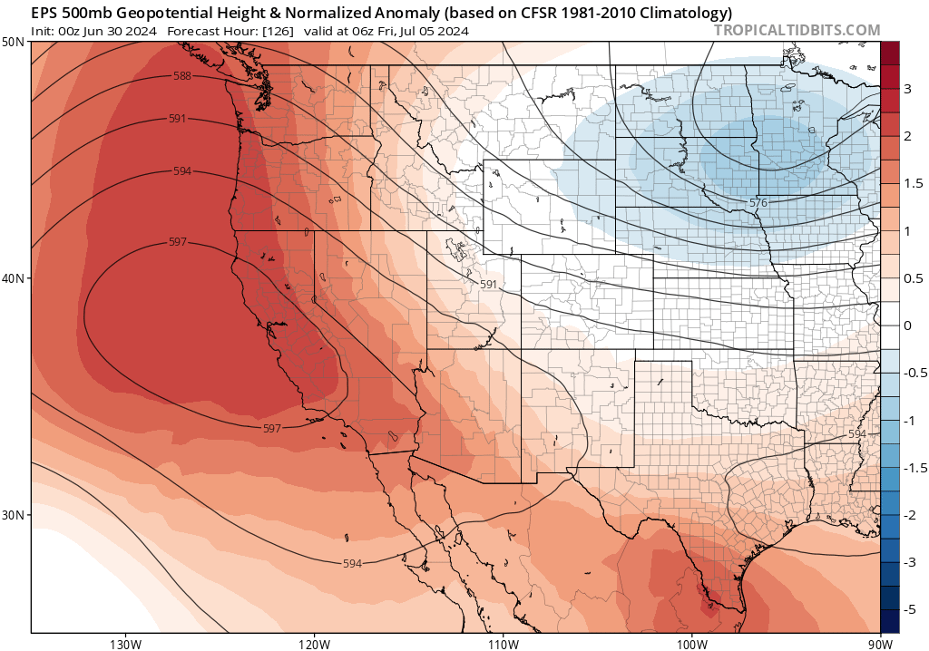
Well, I’ll cut to the chase: it’s going to be very hot, for quite a long time, across most of the CA interior starting tomorrow (July 1). This heatwave will be a bit unusual for the time of year in that the strongest mid-atmospheric ridging will actually start offshore (to the west of CA over the Pacific) before shifting inland and aligning with CA’s Central Valley in the coming days. This means that hotter temperatures will likely make it closer to the coast than during recent heatwaves, and at least initially there will not be much of a cooling seabreeze to speak of (that may change after the 4th as the ridge axis shifts inland).
This heatwave will bring peak temperatures of around 110F to most, if not all, of the Central Valley on at least one day this coming week–and quite a few spots will see 4-5+ days of temperatures at or over 110. Just how how it will get remains to be seen; right now, at least, this does not look like a pattern that will break July monthly /all-time daytime high temperature records (though it could get close in a few spots!)–though quite a few daily high records may fall. Far more significant than the peak intensity of the heat, however, will be its duration and also the magnitude of overnight warmth. In both of those categories, we may well see some July monthly/all-time records broken: consecutive and/or cumulative exceedance of 100/110F degree days could end up in the top 3 historical streaks for parts of the Sacramento/San Joaquin Valley, and nearly all of California may have a period of record “warm minimum” (i.e., record warm overnight “low” temperatures)–even at the coast and in SoCal. The long duration of this event, plus the especially notable/widespread overnight warmth, will amplify both human heat stress and wildfire risk (see below) beyond what a heatwave with peak temperatures in this range might otherwise suggest–and this is a big part of why local NWS offices have issued some strongly-worded/lengthy Excessive Heat Warnings already for this event.
The magnitude of anomalous heat will likely be greatest across interior portions of central and northern CA (at least daily record high temperatures will be possible in a swath from the Antelope Valley northwestward across the San Joaquin Valley and Sacramento Valley, as well as higher elevations in NorCal where overnight warmth may be especially notable). It will also be unusually hot in SoCal, even to the beaches, though generally to a less “anomalous” degree than up north. Still, this will be a statewide heat event and it may last quite a long time–beginning July 1 and perhaps not meaningfully receding until July 8/9 (or even later in some spots).
In fact, this may end up being a “double peaked” heatwave, with the first peak arriving around July 3 and the second one (perhaps focused a little further inland but being even a bit more intense) arriving next weekend (around Jul 7/8). This would occur as the ridge axis shifts inland–cooling the immediate coast and generating a sea breeze but actually making the heat away from the coast even more intense.
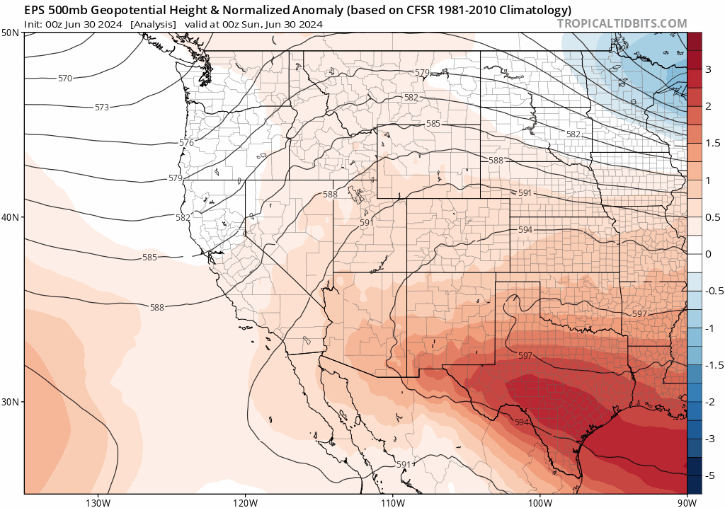
Then, following the initial heatwave’s double peaks, it currently looks like CA will see a transition to “less hot” but “still hotter than average” pattern as ridge axis shifts even further inland toward a configuration more typical of July. Nonetheless: this is still likely to be an anomalously hot pattern, especially across the interior. The coast will likely cool off and may once again become more influenced by cool near-shore SSTs for a while. But across inland areas, as well as at higher elevations, it’s entirely possible that temperatures may be continuously above average for the next 2+ weeks–straight into mid-July.
Fire weather concerns are on the increase in both short and longer term
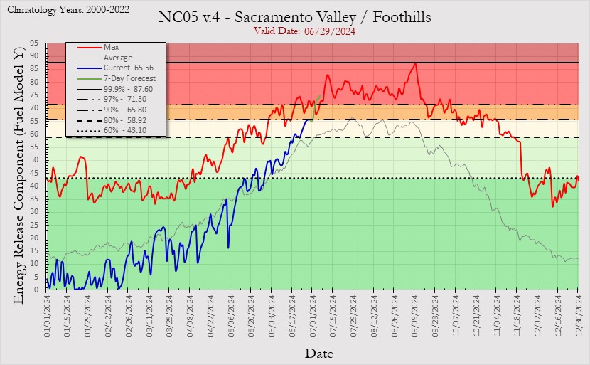
In addition to the heat, fire weather risk will be ramping up this week. In fact, a Red Flag Warning is already in effect for much of lower elevation interior NorCal (below 3,000 feet or so) from Mon-Wed due to the combination of very hot temperatures, low humidity, and breezy northerly winds. In fact, given a confluence of factors, I would expect very high fire risk to persist throughout this heatwave and beyond for a few different reasons.
First, vegetation (particularly fine/herbaceous fuels at elevations below 5,000 feet) are now very dry and cured for the season. In fact, in some parts of NorCal, vegetation “flammability” (as measured by ERCs) will approach record levels for the calendar date several days into the upcoming heatwave. (100hr fuel moistures in some areas will also approach multi-decadal seasonal lows for early July this week.) Also, as discussed earlier in the season, fine fuel “loading” is higher than average this season across most of California following two wet and comparatively mild seasons in 2022 and 2023.
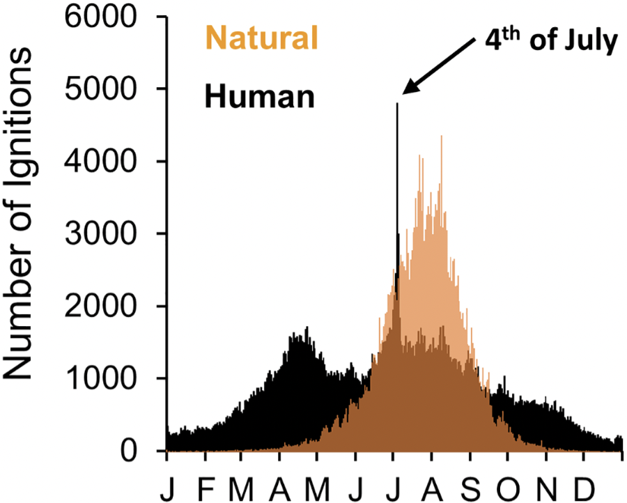
Also notable in this conversation is the fact that this heatwave will directly overlap with the 4th of July holiday. Recent research suggests that the 3-5th of July represents, by a (shockingly?) large margin, the dates with the greatest number of human-caused wildfire ignitions in the United States. This will be particularly consequential since this year these potential firework ignitions will co-occur with a major heatwave and pre-existing high fire risk conditions–which is certainly not the case every year. Thus, the stage is set for some potentially problematic new wildfires in California and much of the West this week. (So when you plan your activities for the 4th this week, please keep in mind just how easy it will be to spark unwanted fires under unusually high risk conditions!)
Additionally, a heads-up for folks in high-risk corridors in NorCal: PG&E has issued a notice that they are considering implementing Public Safety Power Shutoffs in some areas during this period, so please keep that in mind that some will be relying on air conditioning to stay cool during the prolonged heatwave.
This anomalous early season heat will, as I’ve reiterated frequently since March, act in concert with the legacy of two preceding wet years to produce a potentially volatile combination of heavy grass/brush growth and exceptionally dry vegetation as the season progresses. This risk will continue to ramp up through July and August, as earlier noted, and likely peak (unless we are “saved by the bell” in the form of an unexpected early season rain event) during the Sep-Oct window coinciding with offshore wind season. All indications are that the Aug-Oct period will likely be much warmer than average and perhaps also drier than average across much of the interior West–including most of CA–and the observed hot June and soon-to-unfold hot July will set the stage by rapidly drying the landscape. CA is not experiencing a drought at present, and severe drought conditions are unlikely in the state through the end of the calendar year (though stay tuned for 2025). But wildfire risk does not always correspond directly to drought risk, especially in a warming climate that is increasingly being characterized by rapid swings from exceptionally wet conditions and exceptionally warm/dry dry ones in quickly succession. So…be careful out there, and be prepared for Fire Season 2024 to look very different from Fire Season 2022/3.
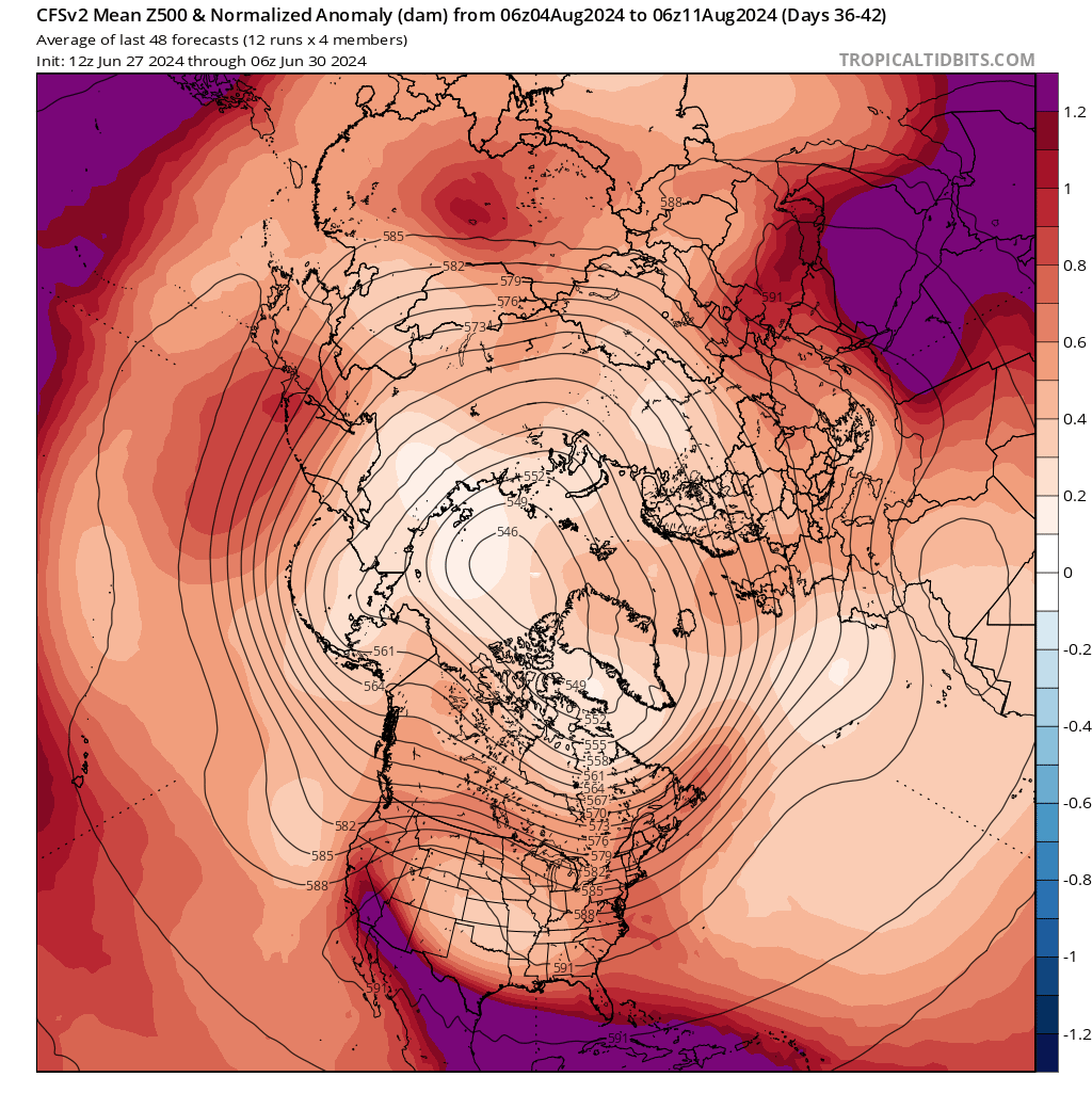
And finally: while I hesitate to use the term “for entertainment purposes only” (since it’s, ah, not very entertaining!), I offer the following for illustrative purposes to show the kind of patterns that the sub-seasonal modeling has recently been spitting out for later this summer. Below is a current snapshot from the average of the last 12 runs of the CFS model depicting projected mid-atmospheric height anomalies for early August. While I encourage folks not to focus on the details, the reason why I’m including this image is to show just how widespread the expected anomalous atmospheric warmth is: throughout the entire Northern Hemisphere, there’s not a single area with GPH lower than the recent multi-decadal average (which already accounts for most of the global warming that occurred prior to 2010). It is, succinctly, a sea of red. In particular, my eye is drawn to the highly anomalous GPH along the western periphery of the Four Corners ridge right at the peak of extreme heat season–including much of California. So while this is but a snapshot of a range of plausible outcomes, it’s consistent with the overall notion that this season could feature long periods of exceptional heat to come. Stay tuned!
Live and interactive “Heatwave Edition” virtual office hour at 2pm PT Mon!
Join me for a live discussion of the then-unfolding heatwave and its short and longer-term implications. I may have an additional “bonus session” later in the week as well if heat/wildfire conditions warrant.
Discover more from Weather West
Subscribe to get the latest posts to your email.