Special Note
Today’s blog update consists of two separate posts. The present post addresses short-term weather concerns (including the record-breaking heatwave/offshore wind event), and a second post later this evening will address the impending El Niño event (and its possible impacts in California) in greater detail.
Ongoing California heatwave and extreme fire weather event
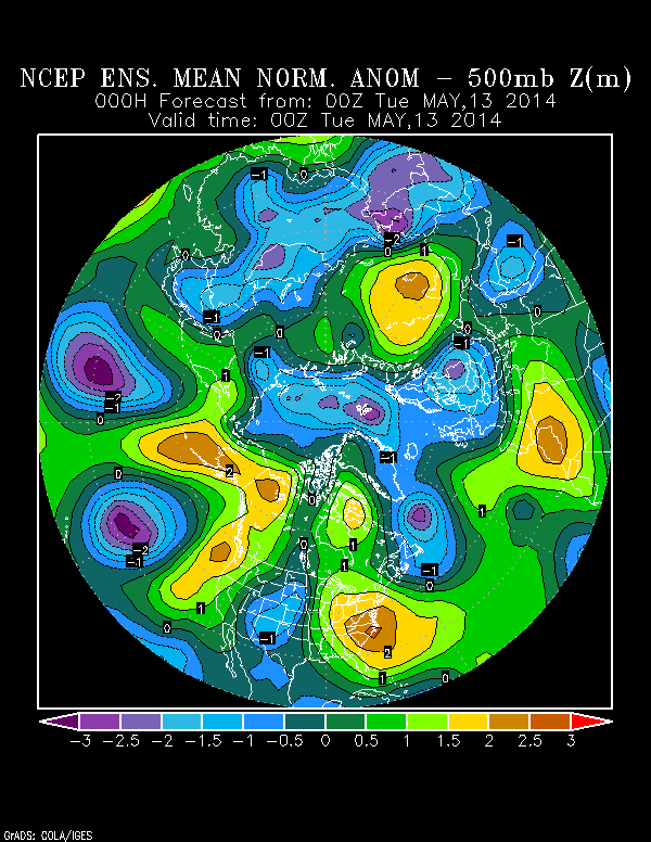
The second major California heatwave of 2014 is now well underway, with record-breaking temperatures occurring or expected over the next 2-3 days over much of California. In addition, strong offshore (Santa Ana) winds are occurring in Southern California–and combined with record-warm temperatures and exceptionally low humidity, dangerously high early-season fire weather conditions are now in place. Temperatures across most of the state are expected to peak on Wednesday, with many warmer areas approaching or exceeding 100 degrees. Even the immediate coastline will be pretty hot–the beaches in Southern California will be in the 90s, and the areas along the water as far north as the Bay Area could approach 90. Temperatures will cool as the heatwave wanes by late week, with substantially cooler conditions expected by the weekend. Around this time, a new Santa Ana wind event may develop as a new region of low pressure drops southeastward just to the north and east of California, possibly bringing a few mountain showers but most notably tightening pressure gradients over California and bringing strong winds once again across a wide region (with attendant fire weather concerns).
A remarkably amplified atmospheric pattern: is this the Ridiculously Resilient Ridge Redux?
It’s pretty unusual to have multiple strong Santa Ana wind events this late in the spring–typically, these events are most common in the early spring and particularly during the late fall months. The recurrence of hot, dry, and windy conditions over California over the past month or so stems from the persistence of a high-amplitude atmospheric flow pattern over much of the Pacific Ocean and North America. This pattern is reminiscent of the one associated with the incredible California dry spell that lasted from January 2013 through early February 2014–associated with the “Ridiculously Resilient Ridge”–which also brought highly anomalous weather conditions to much of North America, including prodigious snowfalls in the upper Midwest and the advection of frigid Arctic airmasses over the eastern half of North America for much of the winter. Interestingly, the eastern Rocky Mountain region just experienced one of its more impressive late-season snowstorms in recent memory.
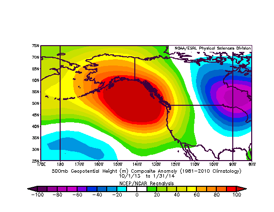
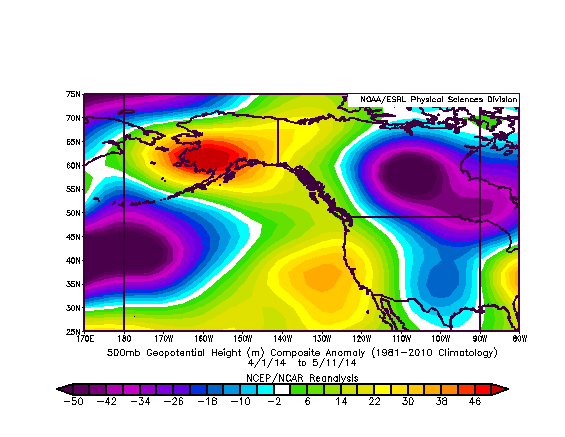
Is this the Ridiculously Resilient Ridge Redux? Well, the key factor in driving the tremendous atmospheric anomalies associated with the “RRR” pattern was the persistence (over many months) of a specific atmospheric configuration. We have a long way to go in order to match the observed persistence of the large-scale atmospheric pattern observed in early 2013 and then again in late 2013 and early 2014. On the other hand, various numerical models are currently suggesting that above-normal temperatures over California will continue more or less for the foreseeable future–certainly for the next couple of weeks, and likely into the first part of summer. The models are also suggesting that geopotential heights over and northwest of California will continue to be above average, though not to the degree experienced during the heyday of the RRR.
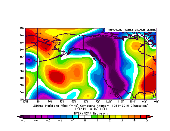
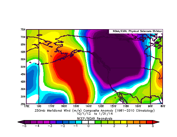
However, it’s also worth keeping in mind that it becomes more difficult to experience really big “ridging” anomalies as we head toward the warm summer months, since average geopotential heights over the North Pacific become higher and less variable relative to the cool and changeable winter months. Possibly for this reason, the anomalous ridging pattern over the past six weeks or so appears to be dominated by a northward extension of the semi-permanent subtropical North Pacific High rather than a vast region of high pressure over the far northeastern Pacific Ocean. Nevertheless: the spatial patterns of meridional (north-south) wind anomalies during each of these time periods–both during the height of the RRR’s winter reign and in again in recent weeks–are strikingly similar to one another over the far northeastern Pacific and across most of North America. This persistent and recurring diople anomaly–characterized by poleward flow over the central North Pacific and equatorward flow centered north and east of California over the North American continent–has garnered a considerable amount of attention in the meteorological community over the past year or so and is the subject of extensive ongoing research. Stay tuned for a more in-depth discussion of this feature (and its role in the ongoing California drought) later this summer.
Finally, there may also be a positive (self-reinforcing) feedback occurring over the extreme drought region centered upon California, since exceptionally dry soil conditions (and low snow cover) over a broad region have led to low evaporation rates and thus increased warming of the lower atmosphere (which increases the height of the atmospheric column on average).Unfortunately, this feedback effect–whereby existing drought conditions lead to warmer air temperatures through reduced evaporation and thus further intensify the drought–will likely continue through the summer and probably until the next substantial rainfall occurs next winter.
Stay tuned for Part II of this special Weather West update later tonight for a more comprehensive update on El Niño.
© 2014 WEATHER WEST
Discover more from Weather West
Subscribe to get the latest posts sent to your email.