One of SoCal’s worst late-season heatwaves on record finally breaking (after breaking records)
I am writing this quick post rapidly from my hotel room, so it’ll rely more heavily on embedded social media threads than usual. But I would be remiss if I didn’t write something up regarding the remarkable weather weekend coming up in Southern California, which has sprung up on us rather quickly due to a northerly shift in Tropical Storm Rachel’s expected trajectory.
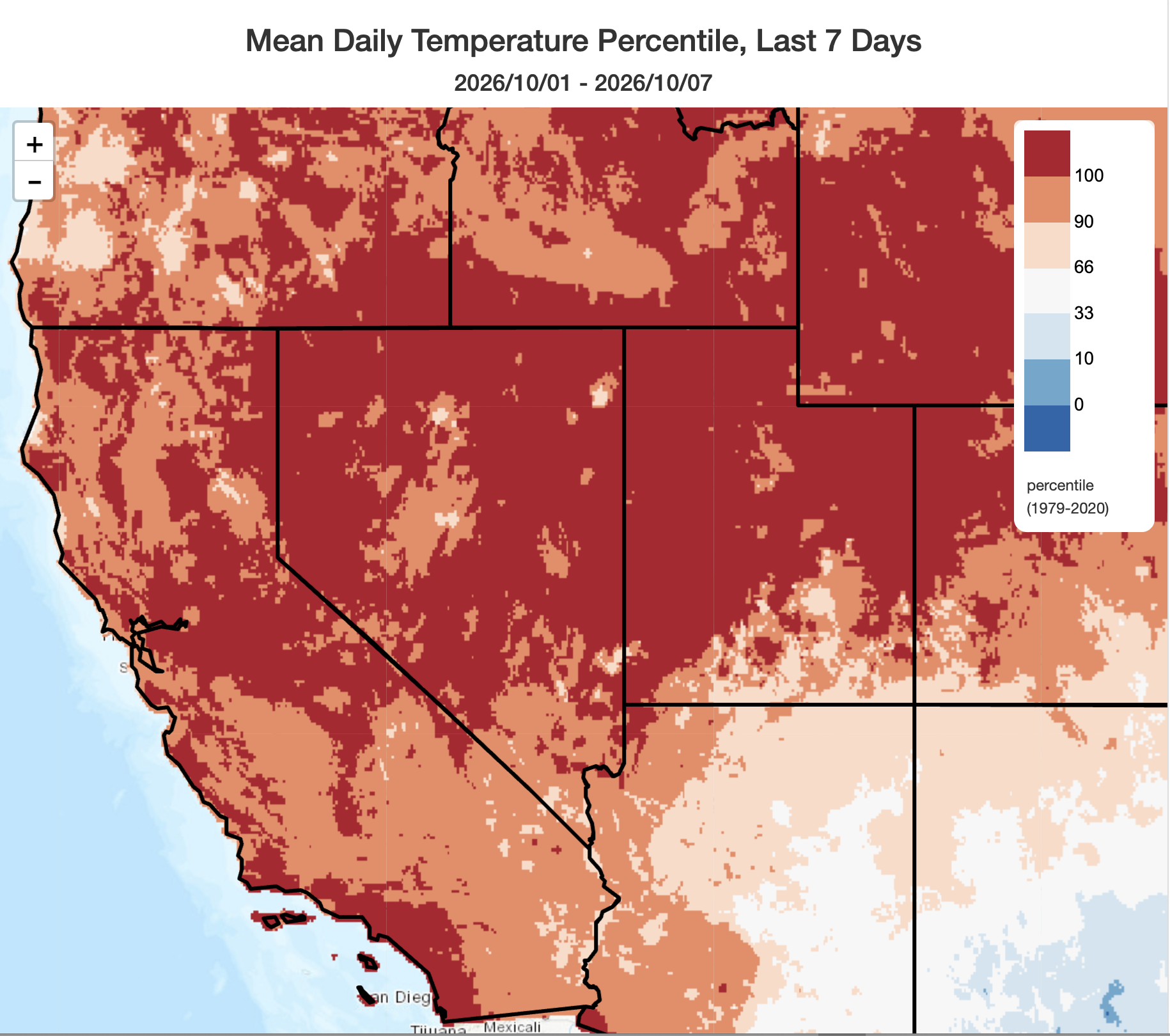
But first: The searing October heatwave that afflicted Southern California (and, really, most of the rest of the U.S. West) during the first 7-8 days of the month is finally ending. And yes, it did break quite a few records, including:
- Downtown Los Angeles exceeded 100F on 5 consecutive days–the longest-ever such streak in October (or so late in the year), and the third longest 100+ streak on record in any month (though this is not a completely fair apples-to-apples comparison, as the observation site moved during period of record)
- San Diego experienced two consecutive 100F+ days, tying its record for October and also marking only the third time this has ever happened, in any month, since at least 1874 (when records began)
- Warmest start to month of October on record for San Diego, Long Beach, Los Angeles, Santa Barbara, Redding, Reno, Salt Lake City, Denver, and many other locations
Fortunately, this heat is now rapidly ending (or will by the weekend, where it is still lingering), and attention will then shift south.
Tropical Storm Rachel will likely make northward turn toward San Diego while slightly re-strengthening; Significant rain/wind/coastal flooding impacts possible from Orange County south and eastward (but with high uncertainty)
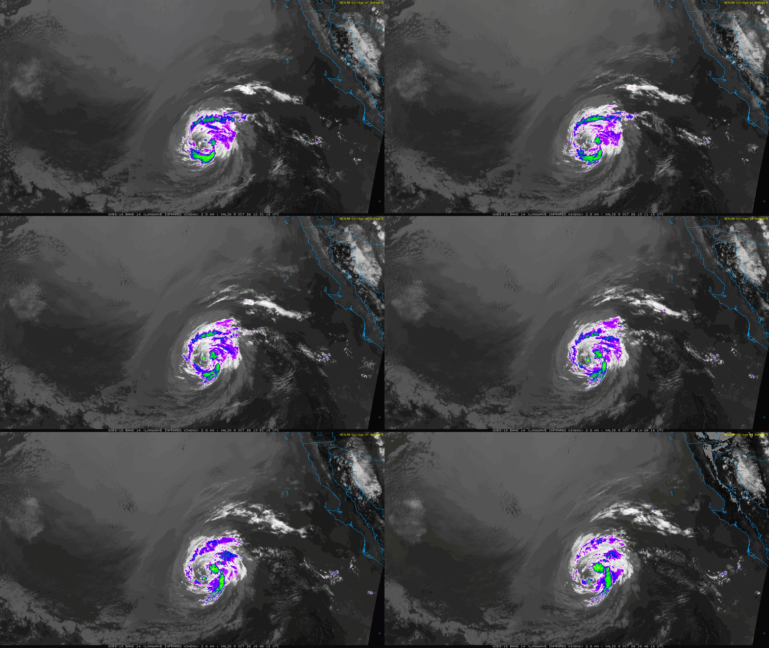
For only the second time in history, NOAA’s National Hurricane Center (NHC) has issued a Tropical Storm Watch for a portion of Southern California (along the coast from the CA/MX border to the OC/SD county line, and then inland across a slightly broader region. The reason: Tropical Storm Rachel is now expected to make a much closer approach on the San Diego region than previously anticipated as an early-season trough forces a last-minute northerly recurve. This trough will also enable strong upper-level divergence, enhancing storm ventilation. Remarkably, despite dry air and a stable atmosphere, this exact trough positioning combined with record-warm ocean temperatures may actually allow Rachel to re-strengthen slightly into a strong tropical storm before landfall, something that is now explicitly predicted by the NHC. That, in itself, is exceptionally unusual in this part of the world.
Long story short: despite considerable lingering uncertainty, there is at least some possibility of a notable tropical storm event near San Diego early Sunday morning, possibly featuring considerable rain, wind, and coastal flooding. See details below.
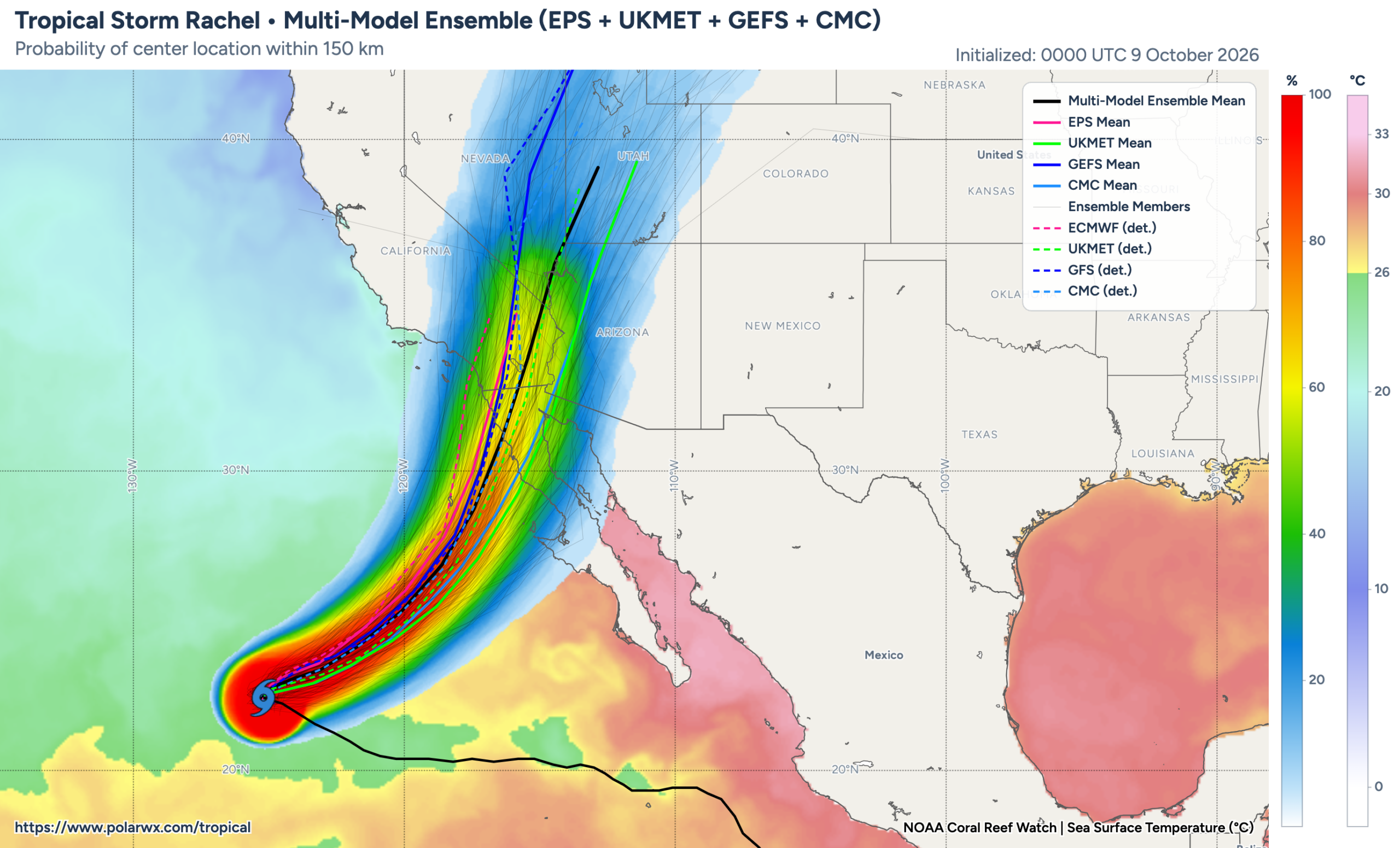
While the models have converged on a track for Rachel implying likely landfall somewhere between Ensenada and San Diego, there is still some chance that the storm could make landfall even farther north (somewhere in San Diego or even Orange County) at tropical storm strength. In fact, some of the most recent deterministic/high-res model runs do suggest a true landfall somewhere in SoCal, with higher-end impacts. At this point, I still think the single likeliest outcome is a moderate-impact scenario for SoCal due to landfall somewhere south of Tijuana, MX–but there is a realistic, and growing, possibility that Rachel does manage to make a last-minute northward turn and hit San Diego County directly.
Notably, as of the most recent update cycle, the ECMWF model ensemble is explicitly predicting a ~50% chance of tropical storm-strength winds in San Diego proper, with around half of members indicating wind gusts over 50 mph (and a small handfull indicating local gusts up to around 70mph). While I still highly doubt lower elevation areas in SoCal will see ~70mph gusts from this system, it remains a theoretical possibility (let’s say around 5%), with the possibility of ~50 mph wind gusts around San Diego somewhat higher. It is also important to note that the upper elevations of San Diego/Orange/Riverside counties are far more likely to see strong and gusty–and potentially damaging winds–this weekend than are lower elevation areas.
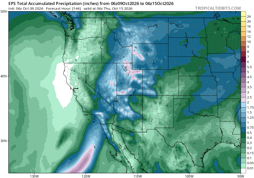
The most certain impact, as is often the case with landfalling tropical storm-strength systems, will be from inland flash flood risk stemming from heavy rainfall. Significant freshwater flooding is unlikely in the major urban metros of SoCal, but this risk will be substantially higher across the lower desert region of southeastern California and western Arizona, where locally torrential bands of convective downpours and associated strong-severe thunderstorms are possible. This could, possibly, also extend to the eastern slopes of the mountains in San Diego, Riverside, and San Bernardino counties depending on the exact but TBD track. Additional heavy rainfall and flooding will be possibly farther north and eastward, into Nevada, Utah, and even Wyoming–but I won’t be able to cover those regions in depth in this rapid-response post.
As I was writing the blog post, I received a flurry of personal anecdotes (reinforced by visuals from live news coverage) that significant coastal inundation was already occurring this morning in SoCal, especially in Los Angeles/Orange/San Diego counties. Ocean water levels have already been running 12-18 inches higher than usual due to the combination of thermal expansion of record-warm seawater plus the additive effect of a large coastally-trapped Kelvin wave that is peaking around now in SoCal. However, I don’t think this is primarily related to Rachel’s effects yet–which is concerning, as a more west/north track for Rachel could bring pretty strong onshore flow and high waves to this region (potentially causing a local storm surge of 1-2 feet, in a worst case, atop the already 1-2 foot water level elevation currently present, and large breaking waves atop that along the immedate shoreline).
Although still-notable moderate coastal flooding is the most likely outcome in coastal SoCal this weekend, there some risk (perhaps 10-20%) of a serious coastal flood event (with locally major/severe) coastal flooding if Rachel does ultimately take the northernmost track indicated by some model members this morning. The National Hurricane Center, in its most recent update, states: “Swells partly generated by Rachel will build along the coast of Southern California and northern Baja California through the weekend. These swells are likely to cause life-threatening surf and rip current conditions, as well as moderate to isolated major coastal flooding, through early next week.” Given the impacts of what we are already seeing today, it would be prudent to prepare for a major coastal flood event this weekend–especially from Long Beach southward.
Broader context: Despite unfavorable atmospheric conditions, Rachel prevails amid record-warm Pacific Ocean waters
Tropical Storm (former hurricane) Rachel has been spinning in the eastern tropical Pacific for many days now. And to be quite honest, it does not look very impressive on satellite imagery right now–the storm is currently visually characterized by compact cyclonic rotation of mix mid-level cloudiness with pockets of modest deeper convective activity (showers and thunderstorms). This is a storm that has clearly ingested dry air in its mid levels, and is not in a particularly moist or unstable ambient atmospheric environment. In a typical year, this is the kind of storm I’d expect to be rapidly weakening and likely fully dissipating before reaching any part of the West Coast.
However, 2026 is not a typical year. Ocean surface temperatures–which provide “fuel” to tropical cyclones–are extremely warm right now in the exact portion of the East Pacific that Rachel will traverse over the next 48 hours. In fact, these waters are more than 10F warmer than average, which is clearly record-breaking. This means that, despite the odds, Rachel will manage to maintain strength, or even strengthen slightly, on final approach toward the CA/MX border region on Sunday.
This year’s extremely warm/record warm oceans in the tropical and subtropical Pacific can be attributed to 3 factors: Recent warming indirectly associated with the extremely strong/record strength El Niño event, additional accumulation of ocean heat from a prolonged multi-month marine heatwave in this region preceding El Niño’s development, and the long-term warming effect from human-caused climate change. This trifecta has radically shifted ocean conditions in this region, and along the southern California coast, this summer and autumn; extreme oceanic warmth will likely persist into winter and may expand farther northward along the West coast as the season progresses.
Finally, and as noted in earlier commentary and blog posts, this exact kind of still-rare set-up is likely to start occurring somewhat less infrequently as the climate continues to warm. It is a remarkable coincidence that the very first published research on this subject directly related to Southern California was published just this year.
Pacific trough and (mid-latitude) low might bring additional showers to parts of CA over the weekend, separate from Rachel, along with much-needed cooling (and some wind, with local fire weather threat)
While the main excitement will certainly be in far SoCal with Rachel and/or its remnants this weekend, the incoming trough and associated non-tropical low pressure system will nonetheless usher in a rather dramatic pattern change across the entire state (and broader West) on it own accord. This includes much cooler and breezier weather statewide, plus the potential for some additional showers across parts of central and southern CA unrelated to Rachel (possibly including areas as far north as central/southern SF Bay region and central/southern Sierra, though totals will likely be quite light this far north. There may also be some moderately elevated fire weather conditions across far NorCal and western Nevada as stronger winds and drier air wrap around the northern/dry side of the low; this is something to keep an eye on, but at the moment does not look to be particularly threatening.
YouTube livestream(s) on Rachel and its potential impacts: Noon Fri and Sun TBD
I am currently in Santa Barbara for various University of California events, but I am taking some time this morning to focus on Rachel. In addition to this blog post, and linked social media threads, I will also attempt a short-notice YouTube livestream on potentially shaky hotel wifi (link below). I may also attempt either a very late night livestream on Sunday night (around 11pm or midnight Pacific Time–possibly the first midnight livestream in Weather West history–but that remains TBD due to active travel. Stay tuned!
Discover more from Weather West
Subscribe to get the latest posts sent to your email.