Pre-monsoonal moisture surge to bring scattered thunderstorms to southern/central CA, w/dry lightning threat in some areas
Much warmer and drier conditions have arrived in NorCal
After a final wave of cool and unstable conditions this past weekend across portions of NorCal, a much hotter and drier pattern is already firmly entrenched as of this writing. Today actually brought a pretty substantial heatwave all the way to the coast in NorCal, with even downtown San Francisco getting into the 90s. Some locations are hitting new daily record highs as of this writing, though values in the traditionally hotter inland locations (though toasty) are not that remarkable for June. But the hot and breezy conditions are rapidly drying out vegetation essentially everywhere right now, in a marked change from what many locations were experiencing up north just a few days ago.
Offshore cut-off low plus advected subtropical moisture = scattered thunderstorms across southern 2/3 of CA, some dry
The big story this week, and the main reason for this last-minute blog post, is the now substantial likelihood of isolated to scattered thunderstorms across much of Central and Southern California over the next 48 hours (early Wednesday into late Thursday). Some of these storms will likely be dry, or nearly so, posing a significant fire weather threat.
In somewhat classical form for a California warm season lightning event, a weak cut-off low is currently developing off the coast of southern California this evening. On its eastern flank, it is entraining a substantial plume of mid-level subtropical moisture–some of which may be even be indirectly sourced from an Eastern Pacific tropical cyclone (soon-to-be Hurricane Celia). This is a little early to be considered a true monsoonal surge, so I’ll call it a “pre-monsoonal moisture incursion.”
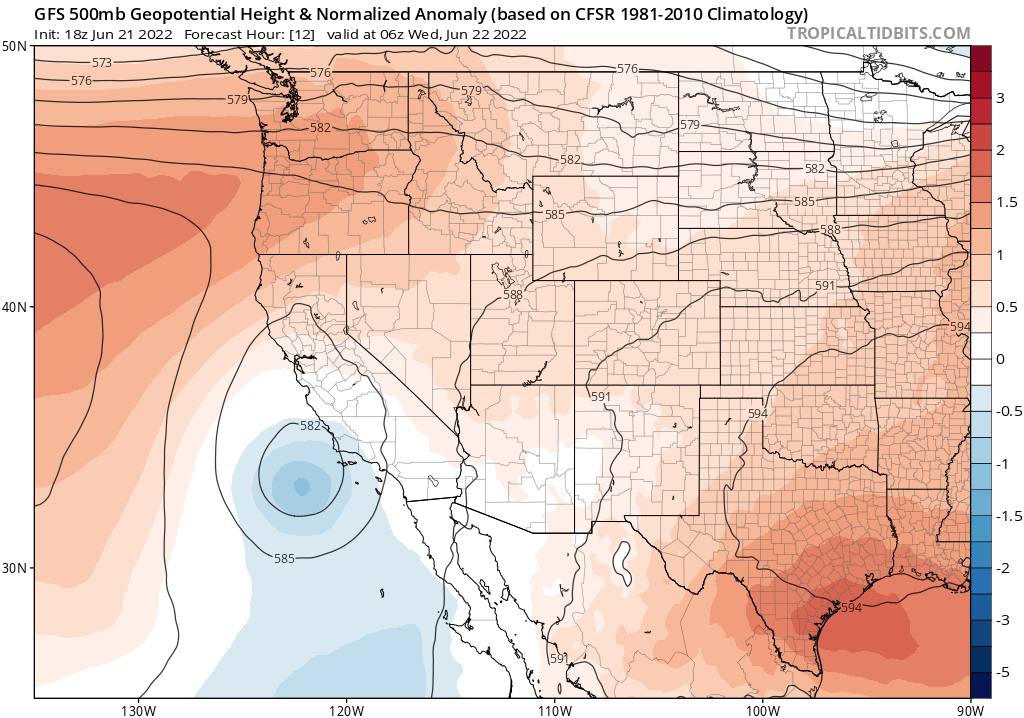
In any event, the position of the low will place a good portion of the southern 2/3 of California into a region of upper-level diffluence, lending a bit of large-scale lift to the inherent instability of the relatively warm and moist airmass. As a result, isolated to scattered thunderstorms are pretty likely to occur over some portion of the region, although the exact placement is uncertain. As of this writing, I think that the most likely region to experience a substantial lightning event would be the San Joaquin Valley, surrounding foothills on the west, south, and east sides of the SJ Valley, and the southern/central Sierra Nevada. Less clear is how much lightning may occur closer to the coast; if it does occur, much of SoCal as well as parts of the Central Coast could be affected. My best guess, right now, is that most of the San Francisco Bay Area is unlikely to see much if any lightning from this (though some isolated strikes are possible in the south and east). The Monterey Bay Area is more likely to see some lightning, however.
In general, these potential thunderstorms will become drier as they move from south to north. So there could actually be a few heavy downpours in SoCal, with low-to-moderate potential for dry lightning (mainly right after storm initiation, before rain cores develop). Across Central CA, however, the risk of dry lightning strikes from some of these cells is probably moderate to high (although coverage will be spotty). The airmass is warmer and drier up north, and model soundings all exhibit classic “inverted V-type” profiles (illustrating a very wide dewpoint depression near the surface layer, and hence very dry sub-cloud layers favoring evaporation of precipitation before it hits the ground). Models are currently suggesting the potential for some surprisingly strong instability by California standards over the San Joaquin Valley and adjacent regions (above 1,000 J/kg), so I think the convection that does develop will have little trouble becoming tall enough to generate some lightning.
Some context for this event, since I know many folks in California have various levels of anxiety stemming from the extraordinary August 2020 dry lightning and subsequent firestorm event: the present situation is very unlikely to have similarly dire consequences, although it could still bring substantial wildfire-related impacts. Why? Well, first of all, 2020 was an exceptional event by almost every metric: the severity of the drought, the record heat that preceded the lightning, the record dryness of the vegetation as the lightning hit, and the incredible number of cloud-to-ground strikes over a relative concentrated area. Of those three conditions, only the first is anywhere near as bad right now as back in 2020.
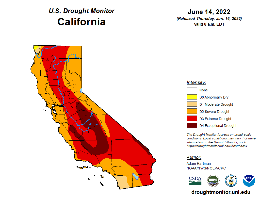
Central CA is unfortunately the peak hotspot of drought severity right now, and it does appear likely that this week’s lightning will be focused directly on the “exceptional” drought swath from the eastern slopes of the Coast Ranges to the western slopes of the Southern Sierra. That’s not good news. However, it’s still relatively early in the season–so vegetation is not as dry as it would be later in the summer or autumn and there is still some green (read: much less flammable) grass and brush at higher elevations and on north-facing slopes. Additionally, I don’t expect to see nearly as many lightning strikes this week as in August 2020 (and those strikes that do occur will mostly occur over a non-overlapping part of the state). For all of these reasons, I am reasonably optimistic that this dry lightning event won’t result in widespread disaster. But I do expect there to be at least a handful of lightning-caused wildfire ignitions–perhaps more than a handful–and some of these may occur in remote areas with lots of highly drought-stressed vegetation and forest mortality. So it is decidedly a mixed picture at the moment. I’ll be following closely on Twitter, as always.
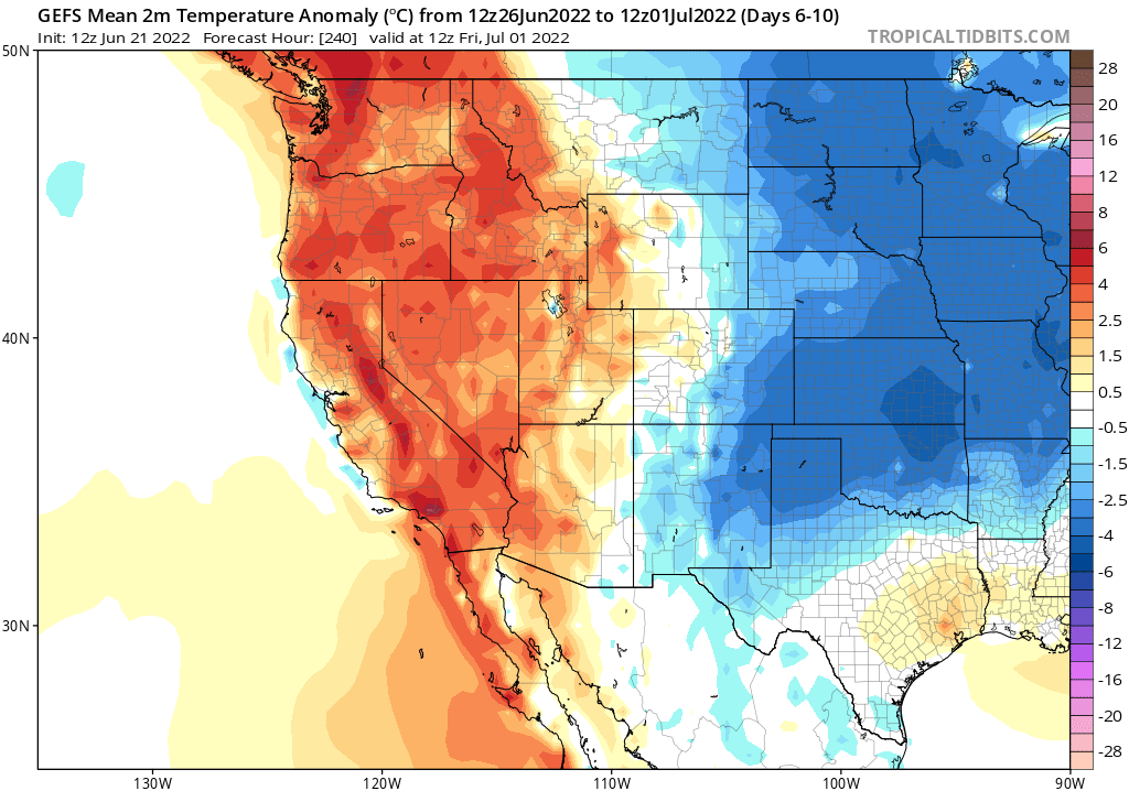
Outlook for rest of June and early July: warmer than average, but not exceptionally so
Once we get through this week’s (dry?) lightning event, I don’t foresee any other major weather events on the immediate horizon. Model ensembles do indicate that warmer-than-average conditions will be the rule, though, so the unusually cool and damp conditions recently experienced in NorCal do appear to be in the rear view mirror and I would continue to expect modest heatwaves during that period.