Hello all! I apologize for the lack of blog updates over the past few months. Now that we’ve entered the traditionally active season for California weather, I hope to have more regular updates moving forward.
Climate Summary
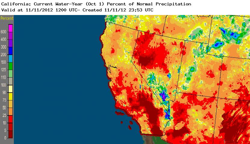
Fall thus far has been pretty typical for much of the state. Weak systems started bringing precipitation to the North Coast and as far south as the Bay Area by mid-October, and significant precipitation has now fallen as far south as the Santa Barbara area. Several convective events brought notable impacts to small regions within the state, including widespread lightning across much of Southern California on two occasions and even a tornado outbreak in the Central Sacramento Valley in early November. Water-year precipitation thus far have been below average for most of the state outside of a small region in the north-central Sierra Nevada Mountains, but deficits are running much lower than this time last year. And, as I’ll discuss shortly, any existing short-term shortfalls should be erased within the next 10 days.
ENSO Update
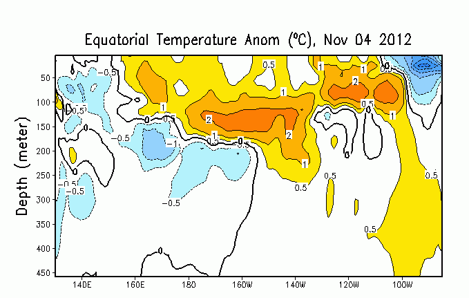
What had over the summer appeared to be promising indicators of an El Nino event for Winter 2012-2013 have since dwindled. Sea surface temperature anomalies are currently minimal in the main regions of interest in the tropical East Pacific, and the medium-term trend has actually been negative. It is unclear exactly why El Nino appears to have fizzled this year, and in the historical record it’s difficult to find other instances of such a dramatic reversal of what at one point appeared to be a strong signal for a modest-strength El Nino event. Dynamical and statistical models, which at one point were pointing to the imminent development of a weak to moderate El Nino event, are now depicting a return to ENSO-neutral conditions for the rest of the winter season. I’m not entirely convinced that this will actually come to fruition, since I was surprised to find significant positive subsurface temperature anomalies persisting across almost the entire Pacific basin in recent weeks. Whether these subsurface anomalies eventually propagate to the surface and initiate a coupled atmospheric response is anyone’s guess right now, though I certainly wouldn’t count on it. In short: a best guess for this winter is an ENSO-neutral environment, which means there are no meaningful signals with which to make a prediction regarding precipitation this winter in California.
Short Term Discussion
It does appear that California is about to enter a period of active weather over the next 5-10 days and possibly lasting for much of the rest of November. Present model forecasts depict a rather strong but very slow-moving low off the coast by mid-week, bolstered by strong upper-level divergence and a strong jet streak on the east side of the system. However, southwesterly flow ahead of the low is expected to be quite dry over California, so even as a 160 kt+ jet streams overhead we can expect mostly dry conditions until the low approaches the coast by Thursday or Friday. By this time, the system will have lost much of its upper-level support and should be quite unimpressive, probably bringing some modest showers to Northern and Central California.
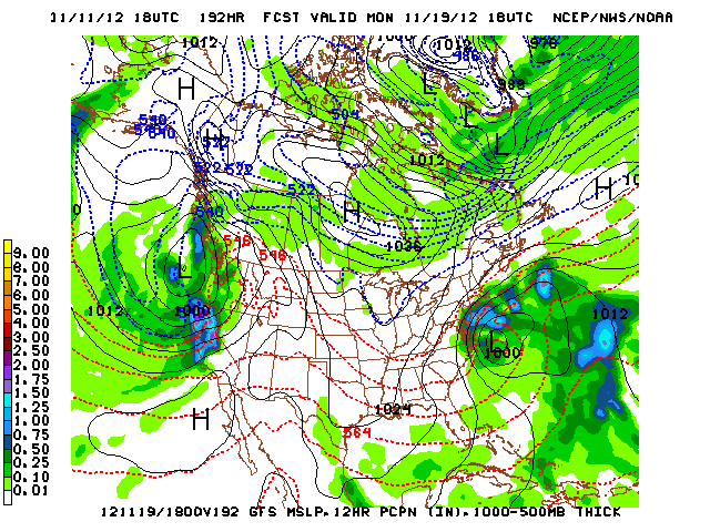
The real story is what may be headed our way next weekend, however. The operational GFS and its ensemble members currently agree on the potential for a strong to very strong storm about seven days from now that would likely impact the entire state. Model solutions over the past several days have been consistently depicting a deep and rather sharp trough off the California coast and appear to be keying into a particular piece of energy that rides down the backside of the trough offshore and morphs into a pretty impressive storm system as it rounds the base on its final approach. Right now, there appears to be the potential for some impressively heavy rains over much of the state next weekend, and depending whether a surface low can form near the base of the trough we may be looking at strong winds as well. Very early indications are that this system could be more convectively unstable than is typical for systems at this time of year, especially given some of the very impressive vertical motion profiles currently depicted. In short: looks like our first real storm of the year is probably on the horizon. And, for what it’s worth, the current ensemble forecasts favor a trough and fairly low-latitude jet persisting across the west coast in the day 10+ period. Stay tuned!
© 2012 WEATHER WEST


