Pineapple Express deluge in Southern California; high risk of Thomas Fire flash floods & mudslides
Very warm & moist atmospheric river heading for SoCal
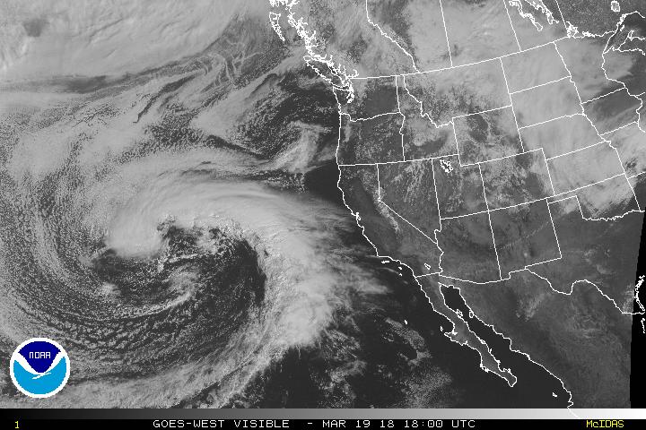
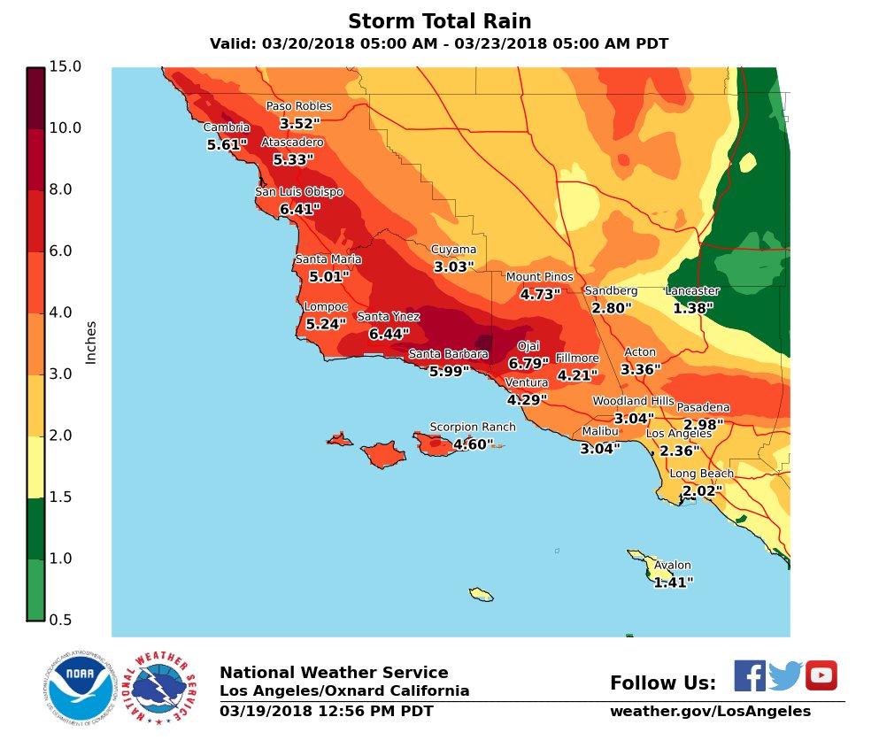
The strongest storm of the year (and perhaps longer) for southern California is rapidly developing over the Eastern Pacific west of California. This system already has a visually spectacular presentation on satellite imagery, and is exhibiting almost textbook structure for an atmospheric river of the “Pineapple Express” variety (so named for the subtropical origins of the associated moisture transport axis near Hawaii). This slow-moving storm will take its time getting here, but will also linger after making landfall on Wednesday. As a result, a long-duration heavy precipitation event is expected from the Central Coast and southern Sierra Nevada (in the north) to the coastal plain in SoCal (in the south). The focus of very heavy precipitation appears to be Santa Barbara and possibly Ventura County (plus or minus 50-100 miles of coastline), but everyone in that above-mentioned region is going to get soaked.
This does *not* appear to be one of those atmospheric rivers (AR) with “all bark and no bite.” Why not? Well, an AR moisture plume is not itself sufficient for heavy precipitation–there still has to be an additional “lifting mechanism” that acts to “squeeze” all of that water out of the atmosphere. Sometimes, a very moist AR can come along that only produces significant precipitation in the mountains (as winds hitting the topography and forcing air to rise upslope is the only thing providing the requisite lift). When a very moist AR “attaches” itself to a strong surface low, though, the associated dynamical lift provided by the associated cold front can produce intense precipitation just about everywhere, which adds to the topographical enhancement.
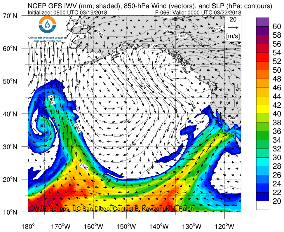
The present storm appears to fall into the latter case: a surface low is expected to spin up west of San Francisco, with frontal lifting combining with favorable jet dynamics aloft to produce what could be a very impressive storm system across the southern half of California Wednesday into Thursday. Models are currently keying on a “frontal wave” late Wednesday as the surface low deepens, which could cause the atmospheric river to temporarily lift back northward before ultimately shifting back southward. The net effect, especially in Santa Barbara County, could be that an initial period of heavy rain will slowly taper off before rapidly intensifying a second time early Thursday when the cold front approaches. It is this second wave of rainfall that may be of most concern, as rainfall rates could easily exceed a half inch per hour. There are also some increasing signs of convective instability, especially on Thursday–and while this may not be enough for thunderstorm activity, it could easily be enough for intense convective bursts of rain with rainfall rates as high as an inch per hour!
The big question: to what extent, for how long, and precisely where will this AR stall out on Wednesday-Thursday? If it moves relatively quickly, flood concerns will be considerably reduced; if it shifts northward, the Thomas Fire burn scar will be at less risk; but if a stall occurs near Santa Barbara–as currently appears possible–then watch out. Right now, it’s not possible to distinguish between these scenarios. But all of them entail quite a bit of water for a broad swath of SoCal. It is worth noting that the majority of major historical flood events in California have been the result of a slow-moving or stalled atmospheric river; such stalling is often as a result of a frontal wave, similar to the one described above. This is a storm to watch very closely on the Central Coast southward to LA County.
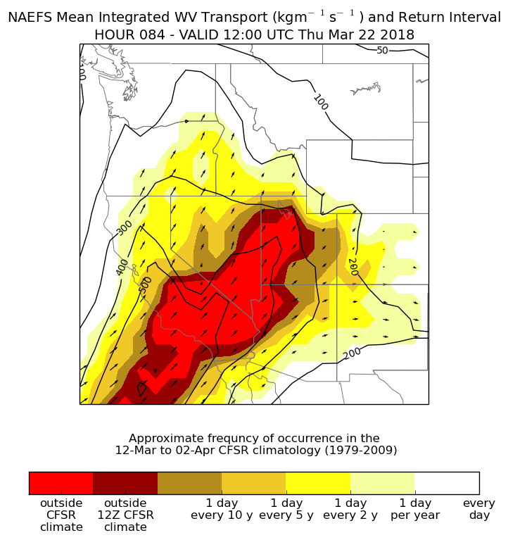
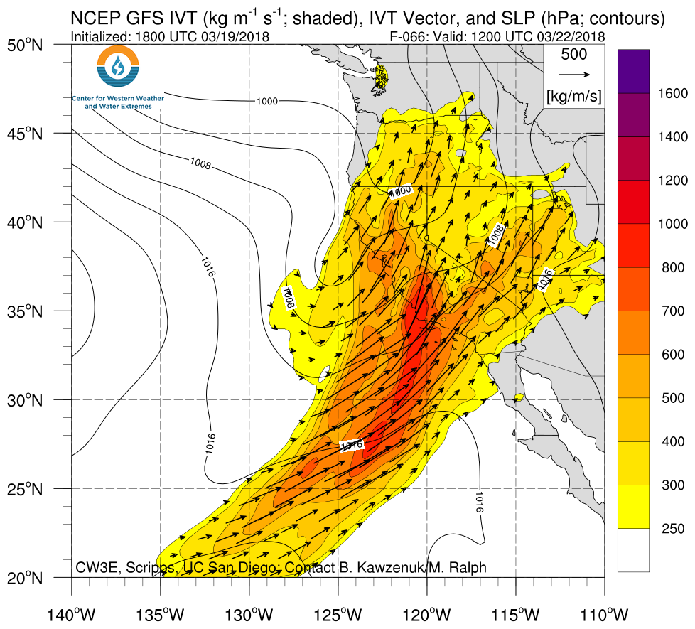
Just how unusual is a storm of this magnitude? When measured in terms of the “vertically integrated water vapor transport” (IVT, i.e. the amount of water in motion in the entire column of air above your head), the inbound atmospheric river may be among the strongest (or perhaps *the* strongest) on record for the months of March or April in Southern California. With water vapor fluxes of this magnitude, it is possible that the models are actually underestimating the precipitation potential with this event (and they’re spitting out some huge totals for much of SoCal already).
The main surface low (or a secondary one behind it) will move ashore later Thursday into Friday, and some thunderstorms may be possible then across much of the state (these may pose an additional SoCal flood threat, especially following all the heavy rain in the prior 48 hours).
Very heavy rainfall is also expected across the southern Sierra Nevada. Notice I said “rain” and not “snow:” with the very warm subtropical airmass, snow levels will be mostly above 7,000-8,000 feet and perhaps as high as 10,000 feet at times, especially in the south. This could act to melt a substantial portion of the lower elevation snowpack, with some local flood issues possible (widespread river flooding is unlikely given dry antecedent conditions). Colder air will filter in toward the end of the storm, especially in NorCal, and some significant snow accumulations could occur down to more reasonable elevations at that time.
Throughout most of NorCal: this storm will bring rain and wind, but won’t be especially extreme or remarkable. Instead, it’ll primarily serve to give a beneficial boost to lagging seasonal rain totals.
*High risk of Thomas Fire flash floods, debris flows, and mudslides*
This will be a dangerous storm for those living near the Thomas Fire burn scar in particular (but there is also substantial risk near other recent SoCal burn scars). This storm will certainly rival–and probably surpass–the January 9th storm in terms of overall precipitation, which resulted in the devastating Montecito debris flow. That does not necessarily mean that the impacts will be as locally devastating (hopefully), since the Montecito event was largely the product of an extremely intense localized downpour. But the risk during this storm will extend across a much broader region, and there is a real possibility of major flash flooding and large debris flows/mudslides (not just minor stream flooding and muddy streets).
Those who read this blog regularly may remember that I expressed considerable concern regarding the debris flow risk in the days before the January 9th storm hit (see “High risk of serious flash flooding, debris flows, and mudslides near Thomas Fire“). This storm concerns me at least as much as the January 9th storm and perhaps somewhat more given the higher expected rain totals, broader region affected, and the potential for the AR to stall out somewhere inopportune. Flash flood watches have now been issued by the NWS for a broad region; some flooding is even possible outside of the fire areas. Mandatory evacuations have also been issued near the Thomas Fire burn scar–not just in Santa Barbara County, but also in Ventura County including parts of the Ojai Valley.
This is a storm to take very seriously near the Thomas Fire burn scar. If you have been advised to evacuate, you should do so. This storm will not be like the last couple of moderate rain events during which evacuations were issued: this one will be much, much stronger, and there is at least the potential for large and destructive debris flows/mudslides near areas denuded of vegetation by recent fires. Heavy rains won’t begin until Tuesday evening, so there’s still time to make preparations and leave the area safely.
Beneficial boost to water supply; recent Sierra Nevada snow gains
It’s not all doom and gloom: the good news is that this storm will dump upwards of 5-7 inches of rain directly on top of the severe drought region in Southern California. Despite the considerable risk to the Thomas Fire vicinity, all that water is desperately needed in this region. Also: while I don’t have time to go into much detail at the moment, the Sierra Nevada snowpack has now recovered substantially from its record-low level in February. It’s still only 47% of average, but that number may continue to tick up in the coming days as new snow falls. I’ll take a closer look at just how close we’ve come to a true March Miracle in a subsequent blog post.
Stay safe out there!
