Dry and drier still: a story of persistent atmospheric ridging
It has been a very dry couple of years across the state of California. With the major exception of the December 2012 deluge in the northern part of the state–which (along with aggressive water management strategies) is largely responsible for the modest water reserves that do remain in the state’s major reservoirs–exceptionally dry conditions have been the rule nearly statewide, even during the traditional winter rainy season. Unfortunately, at least in the short term, there is little evidence of drought-busting rains on the horizon.
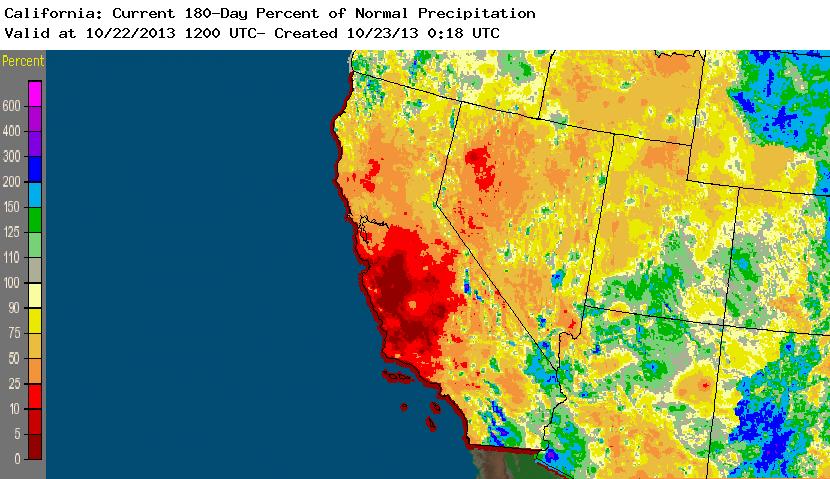
Though much of Southern California has already received some healthy early-season convective precipitation associated of a cut-off low that moved over the California Bight earlier this month, the rest of the state is experiencing an almost entirely dry October–a situation which, while certainly not unprecedented, is not helping to alleviate drought concerns. Current numerical model simulations depict the continued dominance of a strong ridge over East Pacific heading into early November, so prospects for meaningful precipitation are quite low for the next 1-2 weeks.
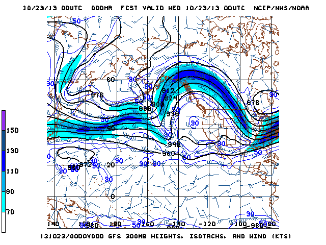
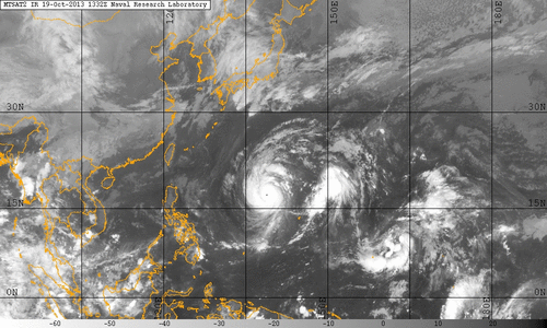
One possible short-term caveat is the current high level of tropical cyclone activity in the Western Pacific. There are currently two active typhoons near Japan–including Category 5 Supertyphoon Lekima–both of which are expected to recurve into the Westerlies before making landfall. This means that a considerable amount of energy will be ingested into already-amplified flow pattern over the Pacific over the next few days. Situations such as these historically give the models trouble in the 5-10 day range, so it’s possible that some of the remnant energy from these typhoons could help dislodge the blocking pattern sooner than expected. In the meantime, check out this impressive infrared satellite imagery centered on the West Pacific:
Long term prospects: ENSO-neutral winter, but potential early signs of change?
The El Nino/Southern Oscillation is one of the most reliable intra-annual indicators for California precipitation, especially when there is either a pronounced La Nina or El Nino event in progress. This year, there is neither–indeed, for the better part of three years, conditions in the tropical Eastern Pacific Ocean have wavered between very weak La Nina conditions and effectively neutral conditions. Current sea surface temperature anomalies (and subsurface anomalies, for that matter) are not impressive, and there is near consensus among the operational numerical models that conditions for Winter 2013-2014 will be ENSO neutral. For this reason, it is difficult to make a meaningful long-range projection for California cool-season precipitation this year on the basis of ENSO.
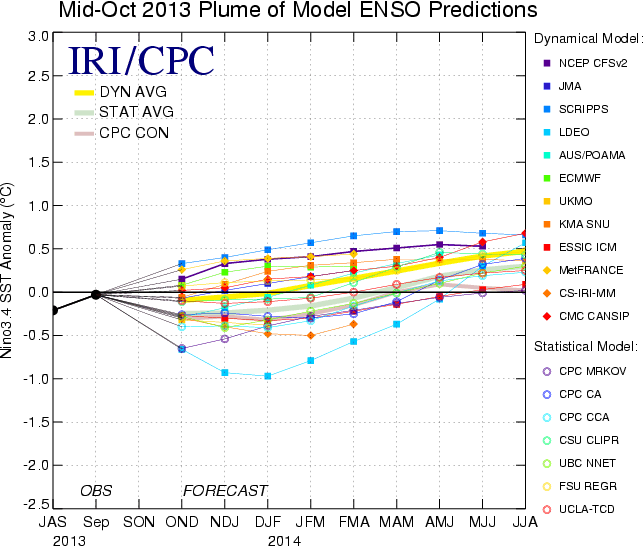
Worth noting, however, is that a majority of numerical models are starting to indicate the emergence of a positive ENSO signal beginning in spring 2014. That is, more models are projecting El Nino conditions for late spring and early summer 2014 than are projecting either neutral or La Nina conditions. The models used to predict ENSO at lead times of greater than six months are subject to considerable uncertainty, but this recent trend appears to be sustained over the last couple of months and may be supported by some observed pooling of subsurface warm water in the western tropical Pacific. While this certainly won’t have any bearing on winter precipitation in 2013-2014, it is something interesting to keep an eye on for next winter.
© 2013 WEATHER WEST
