Overview of recent conditions
Despite the arrival of substantial early-season rainfall across the far northern portions of the state in recent weeks, nearly all of California has experienced much drier than normal conditions thus far this fall.
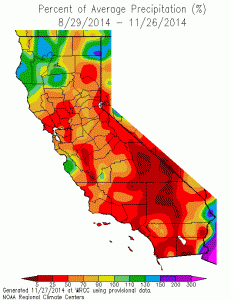
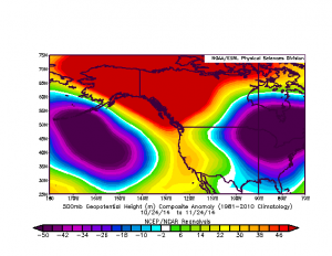
In fact, some of the traditionally wetter parts of northern and central California have missed out on nearly 5-10 inches of liquid precipitation that normally would have fallen by this point in the calendar year–an additional deficit adding to the already enormous one accumulated over California’s driest 3-year period on record, which occurred between late 2011 and late 2014. Much above average temperatures have remained the rule across most of California in recent weeks (driven, in part, by the extremely warm ocean surface temperatures now occurring along the entire West Coast of North America), and a fairly persistent ridging pattern has been in place as well (though it’s not quite as persistent as last year’s now infamous Ridiculously Resilient Ridge). After a 3-year period of exceptional dryness in California–which now exceeds the intensity of any other such period in living memory–prospects for meaningful rainfall and snowfall have been tantalizingly ephemeral as early-season storms have repeatedly failed to live up to their initial expectations.
Strong storm(s?) may affect California over the coming week
As hard as it may be to believe after years of largely nonexistent and (at best) anemic rain events (some localized intense downpours notwithstanding), it finally does appear that a substantial precipitation event may be in the cards for a large portion of drought-stricken California.
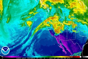
A rather impressive-looking extratropical cyclone is developing in the Northeastern Pacific as of this writing, which may eventually bring a hefty dose of rain, wind, and mountain snow in the 3-6 day period. Model output in recent days has suggested that this storm system–and the one following it–might have the potential to bring quite heavy precipitation across much of the state. However, more recent model runs have started to diverge rather drastically. Some–including the GFS–are suggesting that a large, deep, and slow-moving low will still being heavy precipitation and strong, gusty winds early next week. Others–including the usually-reliable ECMWF–indicate that this low will be less intense and will drop southward well to the west of California, still bringing some precipitation but having much milder impacts overall. On the other hand, the GFS (which is wetter in the short-term) hints at a return to very dry and stable conditions by the end of next week, while the ECMWF (which is considerably drier in the short-term) actually suggests the potential for a very wet pattern to develop in California by the following weekend. At various points, most of these models have suggested the potential for an atmospheric river of some strength to affect some part of the California coast–though there is currently near zero agreement on its actual location, strength, timing, and (indeed) even its existence.
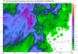
In other words: the specifics of the evolving pattern remain extremely uncertain, despite the fact that the potential rain event is now only a few days out. It’s not entirely surprising that this is the case, since the kind of active pattern at the moment is not being driven by a well-defined, strong subtropical jet. Thus, the incoming low is being driven by considerably weaker steering flow, and relatively small changes in the overall atmospheric flow pattern can lead to large changes in eventual precipitation outcomes in California. The large-scale atmospheric wave pattern remains quite amplified over the Pacific and across much of North America (which has led to some Thanksgiving travel woes along the Eastern Seaboard)–and the numerical models traditionally struggle in such situations. Because this sort of highly-amplified pattern has been common over the past several years, there have been several major “forecast busts” regarding the return of significant precipitation to California–which has been frustrating for those following the day-to-day evolution of the ongoing extreme drought in California.
The big picture: much-needed precipitation still likely this week; extreme drought continues
What’s the overall message here? Well, it still looks pretty likely that most of California will see some rain this week, that the Sierra Nevadas will see some snow, and that said precipitation may be heavy at times in at least some regions.
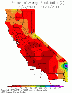
There will probably be some very short-term relief from the ongoing exceptional drought conditions, as fresh snow falls in the mountains, streams in some watersheds begin to flow, and California’s annual wet-season “green-up” begins in earnest in many areas. On balance, though, this is not really the pattern we need to see for sustained, long-term drought relief–especially if the flow pattern over the Eastern Pacific transitions back toward amplified ridging during early December as is currently being suggested by the GFS. Long-term seasonal forecasts by global modeling centers do suggest that the potential exists for an enhanced subtropical jet during the heart of winter, with the coincident increase in the potential for beneficial rainfall in California. Until we actually start seeing such a zonal flow pattern develop in the real atmosphere, however, any drought relief that does occur will probably be in the form of transient (but potentially quite moist) storm systems in a much higher-amplitude flow regime.
In the meantime, enjoy the (probable) rain and snow this weekend and early next week!
© 2014 WEATHER WEST
Discover more from Weather West
Subscribe to get the latest posts sent to your email.